
Title


Angeles National Forest Map (National Geographic Trails Illustrated Map, 811),Used
Sold by Ergodebooks, an authorized reseller.
Returns accepted within 30 days | support@ergodebooks.com
Shipping Information
- Free Standard Shipping — United States only
- Processing Time: 3–5 business days
- Estimated Delivery: 6–10 business days after dispatch
- Double-boxed, fully insured & discreetly packaged
- Tracking number sent via email once dispatched
Returns & Refund
Returns accepted within 30 days of delivery.
Damaged or Defective Item
Free return shipping + replacement or full refund
Wrong Item Received
Free return shipping + replacement or full refund
Change of Mind
Return shipping at customer's expense · 25% restocking fee applies
Payment Option

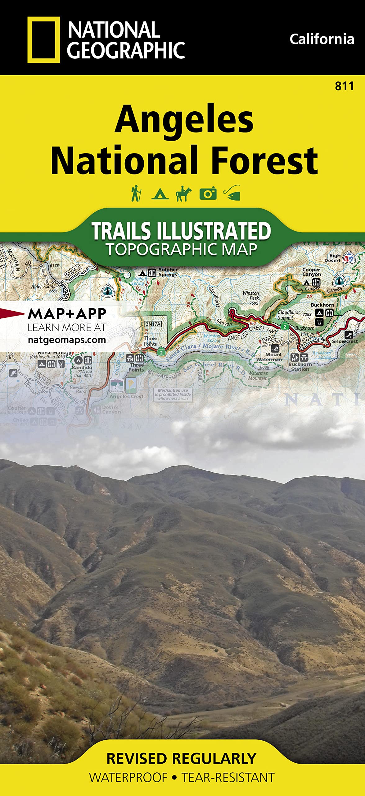
Waterproof TearResistant Topographic MapNational Geographic's Trails Illustrated map of Angeles National Forest provides both unmatched detail and valuable information for outdoor enthusiasts enjoying this diverse recreational area just north of Los Angeles. Expertly researched and created in partnership with the U.S. Forest Service, California State Parks and others, this map features key points of interest in the forest including Magic Mountain, Pleasant View Ridge, San Gabriel, Cucamonga and Sheep Mountain Wilderness Areas; San Gabriel Mountains; Pyramid Lake; and Piru Creek Wild and Scenic River. Also included are nearby California State Parks: Antelope Valley California Poppy Reserve, Ripley Desert Woodland, Castaic Lake State Recreation Area, Hungry Valley State Vehicular Recreation Area and Placerita Canyon.Get off the beaten path and back on again by following the map along precisely mapped trails, labeled with mileage markers and colorcoded according to designated use, whether hiking, mountain biking, ATVing or horseback riding. Highlighted are the nearly 200 miles of Pacific Crest Trail that wind through the area. Your navigation will be aided by the map's contour lines, elevations, labeled peaks and canyons, water features, and clear boundaries between national forest, wilderness and private land. Hundreds of recreation features are marked including areas for camping, fishing, swimming, climbing, canoeing, motor boating, skiing and winter recreation.Every Trails Illustrated map is printed on "Backcountry Tough" waterproof, tearresistant paper. A full UTM grid is printed on the map to aid with GPS navigation.Other features found on this map include: Angeles National Forest, Arcadia, Azusa, Big Dalton Reservoir, Big Tujunga Canyon, Big Tujunga Reservoir, Bouquet Reservoir, Burbank, Castaic Lake, Chatsworth Reservoir, Cogswell Reservoir, Cucamonga Wilderness, Devils Gate Reservoir, Duarte, Glendale, Glendora, La Caada Flintridge, Lake Piru, Los Padres National Forest, Magic Mountain Wilderness, Mint Canyon, Monrovia, Morris Reservoir, Mount San Antonio, Mount Wilson, Palmdale, Pasadena, Piru Creek, Pleasant View Ridge Wilderness, Pyramid Lake, San Bernardino National Forest, San Dimas Reservoir, San Fernando, San Fernando Valley, San Gabriel Mountains, San Gabriel Reservoir, San Gabriel Wilderness, Santa Clarita, Santa Susana Mountains, Sespe Wilderness, Sheep Mountain Wilderness, Sierra Madre, Simi Valley, Soledad Canyon, Upper Van Norman Lake, West Fork San Gabriel River. Map Scale = 1:80,000 Sheet Size = 25.5" x 37.75" Folded Size = 4.25" x 9.25"
⚠️ WARNING (California Proposition 65):
This product may contain chemicals known to the State of California to cause cancer, birth defects, or other reproductive harm.
For more information, please visit www.P65Warnings.ca.gov.
- Q: What are the dimensions of the Angeles National Forest Map? A: The map measures twenty-five point five inches by thirty-seven point seven five inches when unfolded and four point twenty-five inches by nine point twenty-five inches when folded.
- Q: What is the scale of the Angeles National Forest Map? A: The map scale is one to eighty thousand, providing detailed topographic information.
- Q: Who created the Angeles National Forest Map? A: The map is created by National Geographic Maps in collaboration with the U.S. Forest Service and California State Parks.
- Q: How do I use the Angeles National Forest Map? A: You can use the map for navigation by following precisely mapped trails and features, including mileage markers for various activities.
- Q: Is this map suitable for mountain biking? A: Yes, the map includes trails that are color-coded for different types of use, including mountain biking.
- Q: Can I take this map for hiking trips? A: Yes, the Angeles National Forest Map is ideal for hiking as it highlights nearly two hundred miles of the Pacific Crest Trail.
- Q: How do I keep the Angeles National Forest Map safe? A: To keep the map in good condition, store it flat or folded, and avoid exposure to excessive moisture.
- Q: Is the Angeles National Forest Map waterproof? A: Yes, the map is printed on waterproof and tear-resistant paper, making it durable for outdoor use.
- Q: What should I do if my map arrives damaged? A: If the map arrives damaged, contact customer support for return options and possible replacements.
- Q: Can I use the Angeles National Forest Map for GPS navigation? A: Yes, the map includes a full UTM grid, which aids in GPS navigation.
- Q: Does the map include camping locations? A: Yes, the Angeles National Forest Map marks hundreds of recreation features, including camping areas.
- Q: Is this map good for families with children? A: Yes, the map is suitable for families, providing detailed information about various outdoor activities.
- Q: What other activities does the map cover? A: The map covers activities such as fishing, swimming, climbing, canoeing, skiing, and winter recreation.
- Q: Are there any nearby attractions on this map? A: Yes, the map features nearby attractions, including Antelope Valley California Poppy Reserve and Hungry Valley State Vehicular Recreation Area.
- Q: What kind of trails are marked on the map? A: The map marks trails designated for hiking, mountain biking, ATVing, and horseback riding.
- Q: Is the Angeles National Forest Map easy to read? A: Yes, the map includes contour lines, labeled peaks, and clear boundaries, making it user-friendly for navigation.