

Title

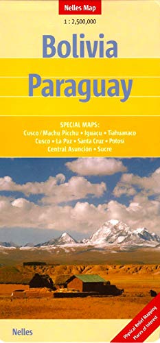
Bolivia and Paraguay Nelles map (English, French, Italian and German Edition),Used
Sold by Ergodebooks, an authorized reseller.
Returns accepted within 30 days | support@ergodebooks.com
Shipping Information
- Free Standard Shipping — United States only
- Processing Time: 3–5 business days
- Estimated Delivery: 6–10 business days after dispatch
- Double-boxed, fully insured & discreetly packaged
- Tracking number sent via email once dispatched
Returns & Refund
Returns accepted within 30 days of delivery.
Damaged or Defective Item
Free return shipping + replacement or full refund
Wrong Item Received
Free return shipping + replacement or full refund
Change of Mind
Return shipping at customer's expense · 25% restocking fee applies
Payment Option

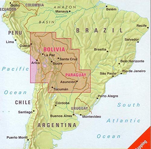
Folded, road & tourist map of Bolivia and Paraguay at 1:2,500,000 scale. National parks, places of interest highlighted, and shadedrelief coloring clearly depicts topography. Insets include Cusco/Machu Picchu, Cusco, La Paz, Santa Cruz, Potosi, Asuncion, & Iguacu. Legend in 4 languages.
⚠️ WARNING (California Proposition 65):
This product may contain chemicals known to the State of California to cause cancer, birth defects, or other reproductive harm.
For more information, please visit www.P65Warnings.ca.gov.
- Q: What languages is the map available in? A: The map is available in four languages: English, French, Italian, and German. This multilingual feature makes it accessible for a diverse range of users.
- Q: What is the scale of the Bolivia and Paraguay map? A: The scale of the map is one to two million five hundred thousand. This scale allows for detailed representation of the regions.
- Q: How many pages does the map have? A: The map has two pages. Each page is designed to provide comprehensive coverage of Bolivia and Paraguay.
- Q: What type of binding does the map use? A: The map uses a folded binding. This design makes it easy to carry and unfold while traveling.
- Q: Who is the author of the map? A: The author of the map is Nelles Verlag. They are known for producing high-quality travel maps.
- Q: Is this map suitable for outdoor activities? A: Yes, the map is suitable for outdoor activities like hiking and sightseeing. It highlights national parks and places of interest.
- Q: Can I use this map for navigation while driving? A: Yes, this map can be used for navigation while driving. Its detailed road information helps in planning routes.
- Q: Is this map appropriate for children? A: Yes, the map is appropriate for children, as it is designed for educational and recreational purposes. It can help them learn about geography.
- Q: How should I store the map to keep it in good condition? A: Store the map flat or folded in a dry place. Avoid exposing it to moisture to prevent damage.
- Q: Can I clean the map if it gets dirty? A: Yes, you can gently wipe the map with a dry cloth. Avoid using water or cleaning solutions.
- Q: What if the map arrives damaged? A: If the map arrives damaged, you should contact customer support for a replacement or return. Ensure to have your order details ready.
- Q: Is this map good for planning trips? A: Yes, this map is excellent for planning trips. It provides detailed information about key locations and attractions.
- Q: Does the map contain shaded relief coloring? A: Yes, the map features shaded-relief coloring. This visual aid clearly depicts the topography of the regions.
- Q: Are there insets included in the map? A: Yes, the map includes insets for key cities like Cusco, La Paz, and Asuncion. This helps users navigate urban areas effectively.
- Q: What is the main purpose of this map? A: The main purpose of this map is to provide travelers with essential information about Bolivia and Paraguay. It highlights tourist attractions and road networks.