
Title


Boulder, Golden Map (National Geographic Trails Illustrated Map, 100)
Processing time: 1-3 days
US Orders Ships in: 3-5 days
International Orders Ships in: 8-12 days
Return Policy: 15-days return on defective items
Payment Option

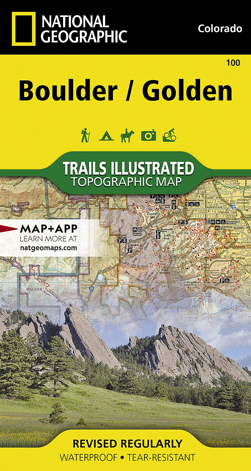
Waterproof Tearresistant Topographic Mapnational Geographic'S Trails Illustrated Map Of Boulder And Golden Provides Detailed Exploration Of Central Colorado'S Front Range. Developed In Collaboration With Local Land Management Agencies, This Map Highlights Boulder Mountain Park, Clear Creek, Golden Gate Canyon State Park, Alderfer/Three Sisters Park, Lookout Mountain, And Red Rocks Amphitheater. Extensive Trail Coverage: Miles Of Marked Trails For Hiking, Biking, Horseback Riding, And Motorized Vehicles. Includes Legends For White Ranch, Alderfer/Three Sisters, And Apex Parks. Detailed Points Of Interest: Covers Boulder Mountain Park, Golden Gate Canyon State Park, Red Rocks Amphitheater, And Communities Like Lyons, Boulder, Golden, Morrison, Aspen Park, And Evergreen. Recreation Features And Scenic Routes: Notes Campgrounds, Trailheads, Interpretive Trails, Boat Launches, Fishing Spots, Swimming Areas, And The Scenic Lariat Loop Byway. Topographic And Practical Information: Provides Contour Lines, Elevations, Trail Etiquette Tips, Survival Advice, And Contact Details For Safe Exploration.Every Trails Illustrated Map Is Printed On Backcountry Tough Waterproof, Tearresistant Paper With A Full Utm Grid For Gps Navigation.Other Features Include Arapaho National Forest, Boulder, Golden, Pike National Forest, Roosevelt National Forest, Superior, And Thorodin Mountain. Map Scale = 1:50,000 Sheet Size = 25.5 X 37.75 Folded Size = 4 X 7.5
⚠️ WARNING (California Proposition 65):
This product may contain chemicals known to the State of California to cause cancer, birth defects, or other reproductive harm.
For more information, please visit www.P65Warnings.ca.gov.
- Q: What are the dimensions of the Boulder, Golden Map? A: The Boulder, Golden Map measures twenty-five and a half inches by thirty-seven and three-quarter inches when fully opened. When folded, it is approximately four inches by seven and a half inches.
- Q: Is the Boulder, Golden Map waterproof? A: Yes, the Boulder, Golden Map is waterproof. It is printed on 'Backcountry Tough' paper, making it tear-resistant and durable for outdoor use.
- Q: How many pages does the Boulder, Golden Map have? A: The Boulder, Golden Map has two pages. This includes detailed topographical information and various points of interest.
- Q: How do I use the Boulder, Golden Map for navigation? A: To use the Boulder, Golden Map, unfold it fully to access the detailed trails and points of interest. Utilize the full UTM grid for GPS navigation.
- Q: Is the Boulder, Golden Map suitable for beginners or experienced hikers? A: Yes, the Boulder, Golden Map is suitable for both beginners and experienced hikers. It provides extensive trail coverage for various skill levels.
- Q: Can I take the Boulder, Golden Map on a bike ride? A: Yes, you can take the Boulder, Golden Map on a bike ride. It includes marked trails for biking along with hiking and horseback riding.
- Q: How should I care for the Boulder, Golden Map to ensure its durability? A: To care for the Boulder, Golden Map, store it in a dry place to maintain its waterproof properties. Avoid excessive folding to prevent wear.
- Q: Does the Boulder, Golden Map have any specific safety features? A: Yes, the Boulder, Golden Map includes survival advice and trail etiquette tips for safe exploration. It also notes campgrounds and trailheads.
- Q: What is the recommended way to store the Boulder, Golden Map? A: The recommended way to store the Boulder, Golden Map is to keep it folded in a dry, cool location. This helps to preserve its condition.
- Q: How does the Boulder, Golden Map compare to other travel maps? A: The Boulder, Golden Map offers detailed topographic information and extensive trail coverage compared to standard travel maps, making it ideal for outdoor enthusiasts.
- Q: Is the Boulder, Golden Map effective for off-road navigation? A: Yes, the Boulder, Golden Map is effective for off-road navigation. It highlights multiple trails suitable for various recreational activities.
- Q: What should I do if the Boulder, Golden Map arrives damaged? A: If the Boulder, Golden Map arrives damaged, contact the seller for a return or exchange. Most sellers provide customer support for such issues.
- Q: Can I use the Boulder, Golden Map for fishing spots? A: Yes, the Boulder, Golden Map includes fishing spots along with other recreational features like campgrounds and swimming areas.
- Q: Does the Boulder, Golden Map cover urban areas like Boulder and Golden? A: Yes, the Boulder, Golden Map covers urban areas including Boulder and Golden, as well as communities like Lyons and Morrison.
- Q: What specific trails are highlighted on the Boulder, Golden Map? A: The Boulder, Golden Map highlights trails in Boulder Mountain Park, Golden Gate Canyon State Park, and other local parks.
- Q: What type of paper is the Boulder, Golden Map printed on? A: The Boulder, Golden Map is printed on 'Backcountry Tough' waterproof and tear-resistant paper, designed for outdoor conditions.