
Title
MICHELIN Croatia and Slovenia Map - Detailed Road and Travel Guide
Sold by Ergodebooks, an authorized reseller.
Returns accepted within 30 days | support@ergodebooks.com
Shipping Information
- Free Standard Shipping — United States only
- Processing Time: 3–5 business days
- Estimated Delivery: 6–10 business days after dispatch
- Double-boxed, fully insured & discreetly packaged
- Tracking number sent via email once dispatched
Returns & Refund
Returns accepted within 30 days of delivery.
Damaged or Defective Item
Free return shipping + replacement or full refund
Wrong Item Received
Free return shipping + replacement or full refund
Change of Mind
Return shipping at customer's expense · 25% restocking fee applies
Payment Option

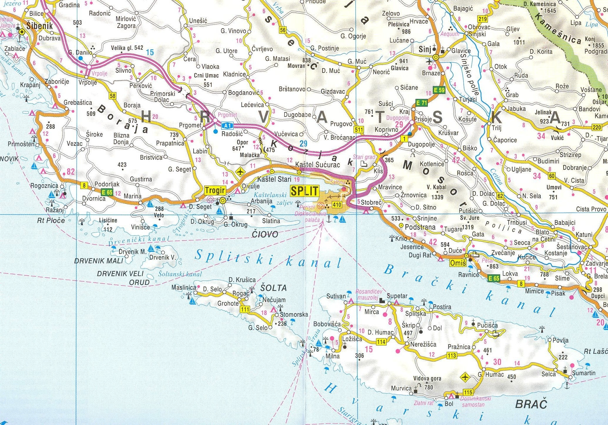
The MICHELIN Folded Road and Travel Map is an essential tool for travelers and adventure seekers. Designed for those who appreciate both detail and functionality, this map provides a comprehensive overview of roads and travel routes at a scale of 1:500,000, making it ideal for road trips, hiking, and exploring new destinations.
This high-quality folded map distinguishes various types of roads, from motorways to secondary roads. Its colorful design not only enhances readability but also enables users to navigate with ease. The map features a detailed legend that includes vital travel information such as railways, funiculars, car ferries, and ascents, ensuring you have all the necessary details for your journey. With an index located on the back, finding specific locations is straightforward and efficient.
Key Features:- Scale: 1:500,000 for precise navigation.
- Colorful design distinguishes various road types, enhancing usability.
- Comprehensive legend includes railways, mountain railways, and funiculars.
- Details on natural sights, National Parks, and World Heritage sites.
- Index on the back for quick location reference.
- Legend available in five languages, including English, catering to diverse users.
- Compact and portable, easy to carry on any journey.
The MICHELIN Folded Road and Travel Map is perfect for outdoor enthusiasts, families planning road trips, and anyone looking to explore new areas without relying solely on digital navigation. Whether you are traversing scenic routes or visiting cultural landmarks, this map offers the reliability and detail you need for a successful journey. Equip yourself with this indispensable travel companion for your next adventure.
⚠️ WARNING (California Proposition 65):
This product may contain chemicals known to the State of California to cause cancer, birth defects, or other reproductive harm.
For more information, please visit www.P65Warnings.ca.gov.
- Q: What are the dimensions of the Croatia and Slovenia map? A: The map measures four point thirty-three inches in length, zero point sixteen inches in width, and nine point seventy-six inches in height. This compact size makes it easy to carry and store.
- Q: How many pages does the Croatia and Slovenia map have? A: The map features two pages. This design provides ample space for detailed information while remaining easy to fold.
- Q: What binding type is used for the Croatia and Slovenia map? A: The map is bound as a traditional map. This allows for easy unfolding and reference during travel.
- Q: How do I use the Croatia and Slovenia map for travel? A: You can use the map by unfolding it to identify routes, attractions, and travel information. The scale of one to five hundred thousand helps with navigation.
- Q: Is the Croatia and Slovenia map suitable for all ages? A: Yes, the map is suitable for all ages. It contains valuable travel information for families, tourists, and adventurers.
- Q: What languages are included in the map's legend? A: The legend is available in five languages, including English. This makes it accessible for a diverse range of travelers.
- Q: How should I store the Croatia and Slovenia map to keep it in good condition? A: Store the map in a cool, dry place to avoid moisture damage. Keeping it folded as intended will also help maintain its condition.
- Q: Can I use the Croatia and Slovenia map in wet conditions? A: No, the map is not waterproof. It's best to keep it dry to prevent damage to the paper and ink.
- Q: What should I do if my Croatia and Slovenia map arrives damaged? A: If the map arrives damaged, contact the seller to inquire about their return policy. Most sellers will offer a replacement or refund.
- Q: Is the Croatia and Slovenia map detailed enough for hiking? A: Yes, the map includes details such as mountain railways, hiking paths, and natural sights, making it suitable for hiking and outdoor activities.
- Q: How is the Croatia and Slovenia map different from other travel maps? A: This map distinguishes various road types and includes a comprehensive legend with points of interest, unlike many standard travel maps.
- Q: What types of roads are indicated on the Croatia and Slovenia map? A: The map distinguishes between motorways and secondary roads, providing travelers with clear navigation options.
- Q: Are national parks marked on the Croatia and Slovenia map? A: Yes, national parks are clearly marked on the map, making it easy for travelers to locate protected areas.
- Q: Does the map include information on lodging and campsites? A: Yes, the map features hostels, camping sites, and other lodging options, catering to various travel needs.
- Q: What type of travel is the Croatia and Slovenia map best for? A: The map is ideal for road trips, hiking, and exploring significant cultural and natural sites in Croatia and Slovenia.
- Q: Is there an index on the back of the Croatia and Slovenia map? A: Yes, the map includes an index on the back, which helps users quickly locate cities, landmarks, and other points of interest.