
Title
Family Maps Of Asotin County, Washington
Sold by Ergodebooks, an authorized reseller.
Returns accepted within 30 days | support@ergodebooks.com
Shipping Information
- Free Standard Shipping — United States only
- Processing Time: 3–5 business days
- Estimated Delivery: 6–10 business days after dispatch
- Double-boxed, fully insured & discreetly packaged
- Tracking number sent via email once dispatched
Returns & Refund
Returns accepted within 30 days of delivery.
Damaged or Defective Item
Free return shipping + replacement or full refund
Wrong Item Received
Free return shipping + replacement or full refund
Change of Mind
Return shipping at customer's expense · 25% restocking fee applies
Payment Option

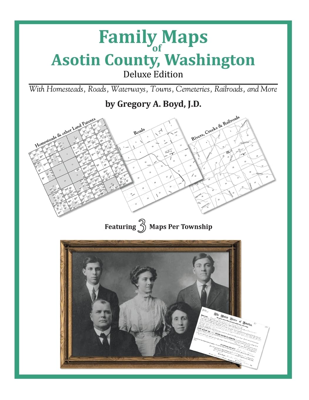
292 Pages With 89 Total Maps Locating Original Landowners In Maps Has Never Been An Easy Taskuntil Now. This Volume In The Family Maps Series Contains Newly Created Maps Of Original Landowners (Patent Maps) In What Is Now Asotin County, Washington, Gleaned From The Indexes Of The U.S. Bureau Of Land Management. But It Offers Much More Than That. For Each Township In The County, There Are Two Additional Maps Accompanying The Patent Map: A Road Map And A Map Showing Waterways, Railroads, And Both Modern And Many Historical Citycenters And Cemeteries. Included Are Indexes To Help You Locate What You Are Looking For, Whether You Know A Person'S Name, A Last Name, A Placename, Or A Cemetery. The Combination Of Maps And Indexes Are Designed To Aid Researchers Of American History Or Genealogy To Explore Frontier Neighborhoods, Examine Family Migrations, Locate Hardtofind Cemeteries And Towns, As Well As Locate Land Based On Legal Descriptions Found In Old Documents Or Deeds. The Patentmaps Are Essentially Plat Maps But Instead Of Depicting Owners For A Particular Year, These Maps Show Original Landowners, No Matter When The Transfer From The Federal Government Was Completed. Dates Of Patents Typically Begin Near The Time Of Statehood And Run Into The Early 1900S. What'S Mapped In This Book (That You'Ll Not Likely Find Elsewhere) . . . 4734 Parcels Of Land (With Original Landowner Names And Patentdates Labeled In The Relevant Map) 8 Cemeteries Plus . . . Roads, And Existing Rivers, Creeks, Streams, Railroads, And Smalltowns (Including Some Historical), Etc. What Years Are These Maps For? Here Are The Counts For Parcels Of Land Mapped, By The Decade In Which The Corresponding Land Patents Were Issued: Decade Parcelcount 1870S 9 1880S 990 1890S 566 1900S 1343 1910S 1002 1920S 565 1930S 123 1940S 5 1950S 3 1960S 3 1970S 79 What Cities And Towns Are In Asotin County, Washington (And In This Book)? Anatone, Asotin, Clarkston, Clarkston Heights, Cloverland, Craige, Grahams Landing, Grouse, Hanson Ferry, Jerry, Mountain View, Rogersburg, Silcott, Theon, Vineland, Zindel (Historical)
⚠️ WARNING (California Proposition 65):
This product may contain chemicals known to the State of California to cause cancer, birth defects, or other reproductive harm.
For more information, please visit www.P65Warnings.ca.gov.
- Q: How many pages are in the book? A: The book contains two hundred ninety-two pages. This includes a total of eighty-nine maps and various indexes to aid research.
- Q: What is the size of the book? A: The book measures eight point five inches in length, eleven inches in height, and zero point six eight inches in width. These dimensions make it a convenient size for reading and referencing.
- Q: What is the binding type of this book? A: The book is available in paperback binding. This makes it lightweight and easy to handle for research purposes.
- Q: Who are the authors of this book? A: The book is authored by Boyd J.D. and Gregory A. This collaboration combines their expertise in historical research and cartography.
- Q: How do I use the maps in this book? A: You can use the maps to locate original landowners and explore historical town layouts. The accompanying indexes help you find specific names or locations.
- Q: Is this book suitable for genealogical research? A: Yes, this book is ideal for genealogical research. It provides detailed maps and indexes that assist in tracing family lineages and historical land ownership.
- Q: How do I care for this book? A: To keep the book in good condition, store it in a cool, dry place away from direct sunlight. Avoid bending pages and clean it gently if needed.
- Q: What should I do if the book arrives damaged? A: If the book arrives damaged, contact the seller for a return or exchange. Most retailers have a policy for handling damaged items.
- Q: Can I use this book for historical research? A: Yes, this book is perfect for historical research. It includes maps from various decades and significant locations in Asotin County.
- Q: What kind of maps are included in the book? A: The book includes patent maps, road maps, and maps showing waterways and railroads. These maps provide a comprehensive view of the area's geography.
- Q: Are there any historical indexes in the book? A: Yes, the book includes indexes that help locate names, places, and cemeteries. This makes it easier to find specific historical information.
- Q: What years do the maps in the book cover? A: The maps cover land patents issued from the 1870s to the 1970s. The book includes parcel counts for each decade.
- Q: Is this book appropriate for children? A: Yes, this book can be suitable for older children interested in history. However, parental guidance is recommended for younger readers.
- Q: How many cemeteries are mapped in this book? A: The book maps eight cemeteries in Asotin County. This information can be valuable for genealogical and historical research.
- Q: What towns are featured in the book? A: The book features towns such as Anatone, Asotin, and Clarkston. It provides insights into their historical significance and development.