
Title


Flaming Gorge National Recreation Area Map (National Geographic Trails Illustrated Map, 704)
Sold by Ergodebooks, an authorized reseller.
Returns accepted within 30 days | support@ergodebooks.com
Shipping Information
- Free Standard Shipping — United States only
- Processing Time: 3–5 business days
- Estimated Delivery: 6–10 business days after dispatch
- Double-boxed, fully insured & discreetly packaged
- Tracking number sent via email once dispatched
Returns & Refund
Returns accepted within 30 days of delivery.
Damaged or Defective Item
Free return shipping + replacement or full refund
Wrong Item Received
Free return shipping + replacement or full refund
Change of Mind
Return shipping at customer's expense · 25% restocking fee applies
Payment Option

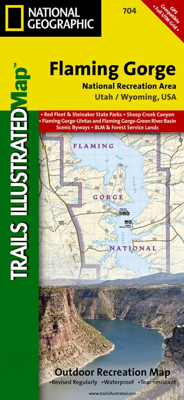
Waterproof Tearresistant Topographic Mapthe Red Cliffs Of The Green River'S Flaming Gorge Stretch From Wyoming'S High Deserts To The Wooded Slopes Of Utah'S Uinta Mountains. Expertly Researched And Created In Partnership With Local Land Management Agencies, National Geographic'S Trails Illustrated Map Of Flaming Gorge National Recreation Area Provides An Unparalleled Tool For Exploring This Magnificent Region. Some Of The Key Areas Of Interest Featured On This Map Include Lucerne Valley; Firehole Canyon; Sheep Creek Canyon Geological Area; Red Fleet And Steinaker State Parks; And A Portion Of The Little Hole National Recreation Trail.Designed With A Wide Range Of Visitors In Mind, This Map Features Detailed Topography With Contour Lines, Shaded Relief And Elevations; Easytoread Trails That Are Marked According To Use; Clearly Defined, Colorcoded Boundaries Of State Parks, Wildlife Areas, Conservation Areas, Indian Reservations, And Private Land; And An Accurate Road Network. If You'Re Taking In The Scenery By Car, Several Scenic Byways And Backways Are Labeled Including Flaming Gorgeuintas, Flaming Gorgegreen River Basin, Sheep Creek Spirit Lake Loop, Sheep Creek Geologic Loop, And Browns Park. Some Of The Many Recreation Features Noted Include Campgrounds, Trailheads, Interpretive Trails, River Access, Boat Launches, Marinas, Fishing Access, And Cross Country Ski Areas.Every Trails Illustrated Map Is Printed On Backcountry Tough Waterproof, Tearresistant Paper. A Full Utm Grid Is Printed On The Map To Aid With Gps Navigation.Other Features Found On This Map Include: Ashley National Forest, Black Mountain, Blacks Fork, Flaming Gorge Dam, Flattop Mountain, Marsh Peak, Uinta Mountains. Map Scale = 1:75,000 Sheet Size = 25.5 X 37.75 Folded Size = 4.25 X 9.25
⚠️ WARNING (California Proposition 65):
This product may contain chemicals known to the State of California to cause cancer, birth defects, or other reproductive harm.
For more information, please visit www.P65Warnings.ca.gov.