
Title
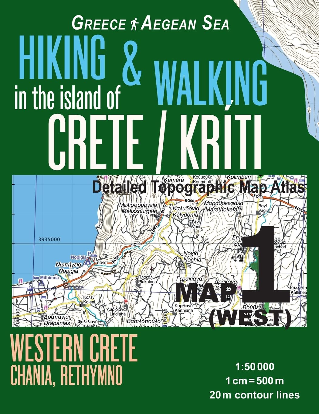
Hiking & Walking In The Island Of Crete/Kriti Map 1 (West) Detailed Topographic Map Atlas 1:50000 Western Crete Chania, Rethymno
Processing time: 1-3 days
US Orders Ships in: 3-5 days
International Orders Ships in: 8-12 days
Return Policy: 15-days return on defective items
Payment Option

Updated Edition. Most Geographic Names In Both English And Greek. Detailed Topographic Map 1:50.000 & 20 Meter Contours For Hiking And Trekking, Printed As An Atlas Book (With Overlapping Pages).Covers The Western Part Of The Island Of Crete (Kriti), Greece. Includes The Area Around Chania, Rethymno, Platanos, Kissamos, Paleochora, Hora Sfakion And Other Villages And Towns. Most Names Are Shown In Both Greek And English.20 Meter Contour Lines, Road Network, Trails & Paths, Transportation, Food, Campsites, Shelters, Guest Houses & Hotels.Mercator Projection With Both Utm And Wgs84 Coordinate Grids.The Map Scale Of 1:50000 (1 Cm = 500 Meters) Provides A Wealth Of Detail While Keeping Low The Weight Of The Atlas Itself. The Large Page Format Of 8.5X11In Minimizes Page Count And Along With An Overlapping Map Design Allows For Comfortable Navigation.The Details Included In The Topographic Maps Of This Atlas Were Specifically Selected To Be Useful For Trekkers, Hikers And Walkers Of All Interests, And Make It Easy To Plan And Enjoy Both Short Excursions And Hikes As Well As Long Multiday Adventures Along The Main Marked Routes And/Or Adjacent Trails And Paths, Which Are Also Shown On The Maps.With This Ultralight Atlas You Will Always Have A Detailed, Reliable, Informationrich, Batteryindependent, Shatterproof Map For Your Adventure.
⚠️ WARNING (California Proposition 65):
This product may contain chemicals known to the State of California to cause cancer, birth defects, or other reproductive harm.
For more information, please visit www.P65Warnings.ca.gov.
- Q: What is the scale of the map in the Hiking & Walking in the Island of Crete atlas? A: The map scale is 1:50000, which means 1 centimeter on the map represents 500 meters in reality.
- Q: Is the atlas suitable for both hiking and trekking? A: Yes, the atlas is specifically designed for hikers and trekkers, featuring detailed topographic maps with contour lines and paths for various skill levels.
- Q: What areas does this map cover? A: The map covers the western part of Crete, including regions around Chania, Rethymno, Platanos, Kissamos, Paleochora, and Hora Sfakion.
- Q: Are the geographic names in the atlas provided in multiple languages? A: Yes, most geographic names are shown in both English and Greek, facilitating easier navigation for different users.
- Q: What kind of details can I expect from the topographic maps? A: The maps include 20 meter contour lines, road networks, trails, paths, transportation options, food sources, campsites, shelters, guest houses, and hotels.
- Q: What is the binding type of the atlas? A: The atlas is bound in paperback, making it lightweight and portable for outdoor use.
- Q: When was the Hiking & Walking in the Island of Crete atlas published? A: The atlas was published on March 15, 2018.
- Q: How large is the atlas, and does it affect usability? A: The atlas measures 8.5 by 11 inches, which minimizes page count and allows for comfortable navigation with overlapping map designs.
- Q: Is the atlas water-resistant or durable for outdoor conditions? A: While the atlas is described as shatter-proof, it is recommended to keep it protected from extreme weather conditions as it is not explicitly water-resistant.
- Q: Can this map be used for planning multi-day hikes? A: Yes, the atlas includes detailed routes and paths suitable for both short excursions and long multi-day adventures, making it versatile for different hiking plans.