Title

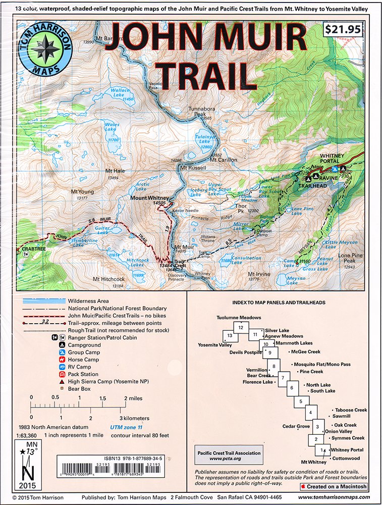
John Muir Trail Mappack: Shaded Relief Topo Maps (Tom Harrison Maps)
Delivery time: 8-12 business days (International)
Shaded Relief Topo Maps Packet Of The Famous Sierra High Route That Will Take Hikers From Mount Whitney To Yosemite, Ca. Well Marked Trails Over Usgs Topo Maps That Were Beautifully Enhanced With Shaded Relief To Better Distinguish Details. Scale 1:630360. 1 Inch On Map Equals 1 Mile. Whitney Portal, Symmes Creek, Onion Valley, Oak Creek, Taboose Creek, North And South Lakes, Vermilion, Bear Creek, Florence Lake, Pine Creek, Mono Pass, Mcgee Creek, Devils Postpile, Mammoth Lakes, Agnew Meadows, Silver Lake, Tuolomne Meadows, And Finally The Yosemite Valley. Gps Compatible! Complete Utm Grid.
By changing our most important processes and
products, we have already made a big leap forward. This ranges from the
increased use of more sustainable fibers to the use of more
environmentally friendly printing processes to the development of
efficient waste management in our value chain.
⚠️ WARNING (California Proposition 65):
This product may contain chemicals known to the State of California to cause cancer, birth defects, or other reproductive harm.
For more information, please visit www.P65Warnings.ca.gov.
Shipping & Returns
Shipping
We ship your order within 2–3 business days for USA deliveries and 5–8 business days for international shipments. Once your package has been dispatched from our warehouse, you'll receive an email confirmation with a tracking number, allowing you to track the status of your delivery.
Returns
To facilitate a smooth return process, a Return Authorization (RA) Number is required for all returns. Returns without a valid RA number will be declined and may incur additional fees. You can request an RA number within 15 days of the original delivery date. For more details, please refer to our Return & Refund Policy page.
Warranty
We provide a 2-year limited warranty, from the date of purchase for all our products.
If you believe you have received a defective product, or are experiencing any problems with your product, please contact us.
This warranty strictly does not cover damages that arose from negligence, misuse, wear and tear, or not in accordance with product instructions (dropping the product, etc.).
Secure Payment
Your payment information is processed securely. We do not store credit card details nor have access to your credit card information.
We accept payments with :
Visa, MasterCard, American Express, Paypal, Shopify Payments, Shop Pay and more.
Secure Payment
Your payment information is processed securely. We do not store credit card details nor have access to your credit card information.
We accept payments with :
Visa, MasterCard, American Express, Paypal, Shopify Payments, Shop Pay and more.
Related Products
You may also like
Frequently Asked Questions
- Q: What is included in the John Muir Trail Map-Pack? A: The John Muir Trail Map-Pack includes a series of shaded relief topographic maps that cover the Sierra High Route, specifically from Mount Whitney to Yosemite, California.
- Q: What scale are the maps in the John Muir Trail Map-Pack? A: The maps in the pack are at a scale of 1:630360, meaning that one inch on the map represents approximately one mile in reality.
- Q: Are the maps GPS compatible? A: Yes, the maps are GPS compatible and feature a complete UTM grid for easy navigation.
- Q: How many maps are included in the pack? A: The John Muir Trail Map-Pack contains 13 maps specifically designed for hiking the Sierra High Route.
- Q: Who is the author of the John Muir Trail Map-Pack? A: The maps are authored by Tom Harrison, a well-known publisher of outdoor maps.
- Q: What is the publication date of the John Muir Trail Map-Pack? A: The John Muir Trail Map-Pack was published on July 8, 2015.
- Q: What regions are covered by the maps in this pack? A: The maps cover various regions including Whitney Portal, Symmes Creek, Onion Valley, and Yosemite Valley among others.
- Q: What type of binding does the map pack have? A: The John Muir Trail Map-Pack is bound as a map, which allows for easy handling and unfolding during hikes.
- Q: Is the John Muir Trail Map-Pack suitable for beginners? A: Yes, the maps are well-marked and designed to assist both beginner and experienced hikers in navigating the beautiful Sierra High Route.
- Q: Can the maps be used in different weather conditions? A: The maps are durable and designed for outdoor use, making them suitable for a variety of weather conditions, though it is advisable to protect them from excessive moisture.
