
Title


John Muir Trail Topographic Map Guide (National Geographic Topographic Map Guide) (National Geographic Topographic Map Guide, 10
Sold by Ergodebooks, an authorized reseller.
Returns accepted within 30 days | support@ergodebooks.com
Shipping Information
- Free Standard Shipping — United States only
- Processing Time: 3–5 business days
- Estimated Delivery: 6–10 business days after dispatch
- Double-boxed, fully insured & discreetly packaged
- Tracking number sent via email once dispatched
Returns & Refund
Returns accepted within 30 days of delivery.
Damaged or Defective Item
Free return shipping + replacement or full refund
Wrong Item Received
Free return shipping + replacement or full refund
Change of Mind
Return shipping at customer's expense · 25% restocking fee applies
Payment Option

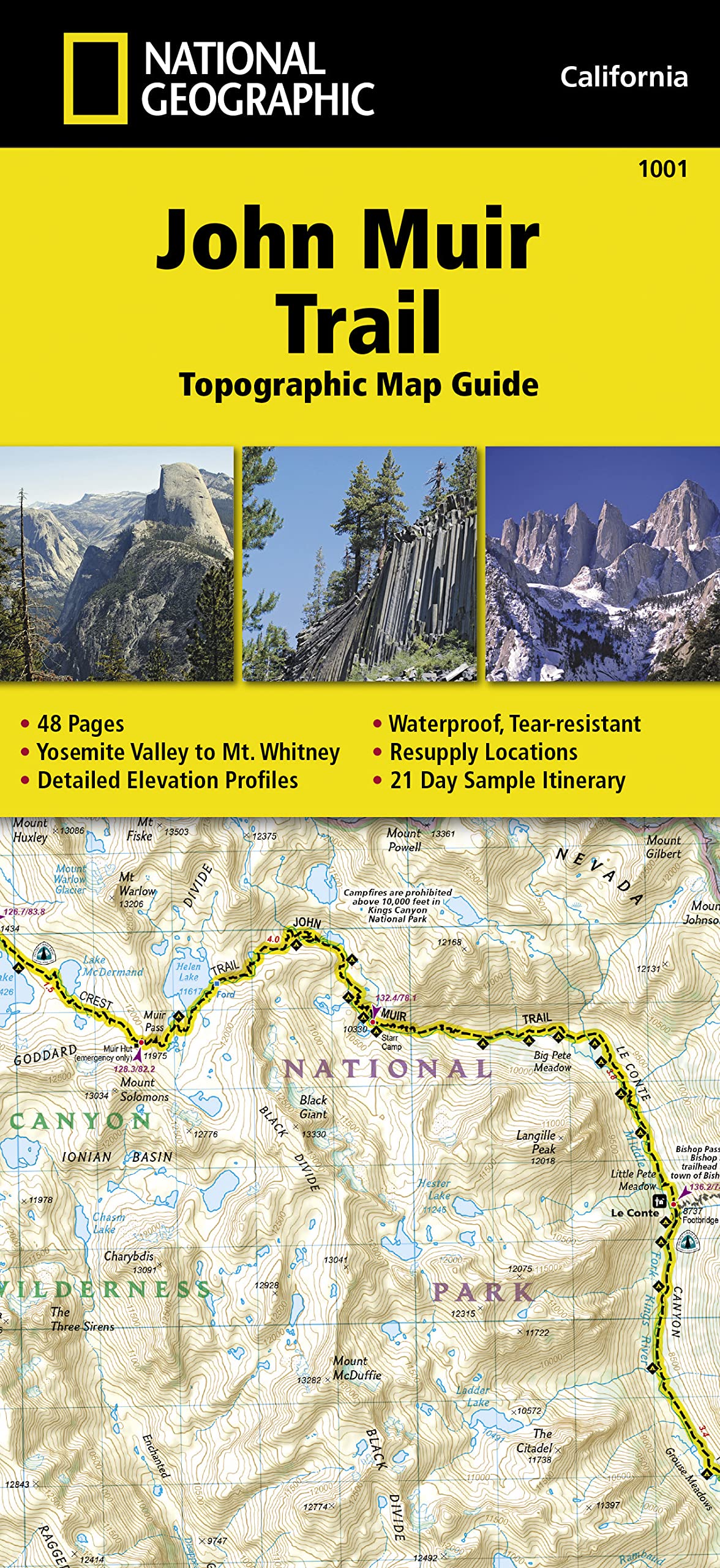
Waterproof Tearresistant Topographic Mapnational Geographic'S Map Guide Of The John Muir Trail Is An Indispensable Tool For Navigating One Of The Most Famous Trails In The United States. Expertly Researched And Created In Partnership With Local Land Management Agencies, This Product Provides Detailed Topographic Maps, Interesting History, A Waypoint Table, Information About Wilderness Safety, And Key Points Of Interest You Will Encounter Along The Trail. A Resupply Location Chart Shows Shipping Address/Contact Information, Distances, And Services Available At Each Resupply Point. Each Map Page Has A Detailed Trail Profile That Shows The Elevation Changes You Will Encounter. Also, The John Muir Trail Is Highlighted And Centered On Each Page So You Can Easily Track Your Progress.The Maps Start At The Northern Terminus In Yosemite Valley And Progress Along The Ridge Of The Sierra Nevada, Past Devils Postpile, And End At The Highest Point In The Lower 48 On The Top Of Mount Whitney. Along The Way You Will Pass Through; Yosemite National Park, Ansel Adams Wilderness, Devils Postpile National Monument, John Muir Wilderness, Kings Canyon National Park, And Finally, Sequoia National Park And Mount Whitney. A 21Day Sample Itinerary Is Included As Well.Every Topographic Map Guide Is Printed On Backcountry Tough Waterproof, Tearresistant Paper. A Full Utm Grid Is Printed On The Map To Aid With Gps Navigation.Other Features Found On This Map Include: Ansel Adams Wilderness, Bridalveil Fall, El Capitan, Illilouette Falls, Inyo National Forest, John Muir Wilderness, Kings Canyon National Park, Lake Thomas A Edison, Lower Yosemite Fall, Middle Palisade, Mount Agassiz, Mount Darwin, Mount Muir, Mount Pinchot, Mount Powell, Mount Ritter, Mount Russell, Mount Tyndall, Mount Whitney, Mount Williamson, Nevada Fall, North Palisade, Ribbon Fall, Ritter Range, Sequoia National Park, Sierra National Forest, Sierra Nevada, Split Mountain, Upper Yosemite Falls, Vernal Fall, Yosemite National Park, Yosemite Valley. Map Scale = 1:63,360 Folded Size = 4.25 X 9.25
⚠️ WARNING (California Proposition 65):
This product may contain chemicals known to the State of California to cause cancer, birth defects, or other reproductive harm.
For more information, please visit www.P65Warnings.ca.gov.
- Q: What is the size of the John Muir Trail Topographic Map Guide? A: The folded size is four point twenty-five inches by nine point twenty-five inches. This compact size makes it easy to carry while hiking.
- Q: How many pages does this map guide have? A: The map guide contains forty-eight pages. This includes detailed maps and helpful information for your hike.
- Q: What type of material is the map guide made from? A: The map guide is printed on waterproof and tear-resistant paper. This ensures durability during outdoor use.
- Q: How do I use the John Muir Trail Topographic Map Guide? A: You can use this map guide for hiking and navigation along the John Muir Trail. It provides detailed topographic maps and waypoints.
- Q: Is this map guide suitable for beginners? A: Yes, this map guide is suitable for hikers of all skill levels. It includes essential information and a sample itinerary.
- Q: Can I rely on this map guide for GPS navigation? A: Yes, it features a full UTM grid printed on the map. This aids in GPS navigation for more accurate positioning.
- Q: How should I care for the John Muir Trail Topographic Map Guide? A: Keep the map guide dry and store it in a cool place. Its waterproof material helps prevent damage during outdoor use.
- Q: Is the map guide safe to use in wet conditions? A: Yes, the map is waterproof. This feature allows it to withstand wet conditions without being damaged.
- Q: What should I do if the map guide arrives damaged? A: If the map guide is damaged upon arrival, contact customer service for assistance. They can help with returns or exchanges.
- Q: How does this map compare to other hiking guides? A: This map guide is specifically tailored for the John Muir Trail, offering detailed topographic information not found in general hiking guides.
- Q: Does the map guide include historical information? A: Yes, it contains interesting historical notes about the John Muir Trail. This context enhances your hiking experience.
- Q: Is there a resupply location chart in the guide? A: Yes, there is a resupply location chart. It provides shipping addresses, distances, and available services along the trail.
- Q: Can I get a sample itinerary from the map guide? A: Yes, the guide includes a twenty-one-day sample itinerary. This is helpful for planning your hike.
- Q: What parks does the John Muir Trail pass through? A: The trail passes through several parks, including Yosemite National Park and Sequoia National Park. These locations offer stunning views.
- Q: Is this map suitable for family hikes? A: Yes, it is suitable for family hikes as it provides essential safety and navigation information. This makes it ideal for various skill levels.