
Title


Mantila Sal National Forest Map (National Geographic Trails Illustrated Map, 703)
Sold by Ergodebooks, an authorized reseller.
Returns accepted within 30 days | support@ergodebooks.com
Shipping Information
- Free Standard Shipping — United States only
- Processing Time: 3–5 business days
- Estimated Delivery: 6–10 business days after dispatch
- Double-boxed, fully insured & discreetly packaged
- Tracking number sent via email once dispatched
Returns & Refund
Returns accepted within 30 days of delivery.
Damaged or Defective Item
Free return shipping + replacement or full refund
Wrong Item Received
Free return shipping + replacement or full refund
Change of Mind
Return shipping at customer's expense · 25% restocking fee applies
Payment Option

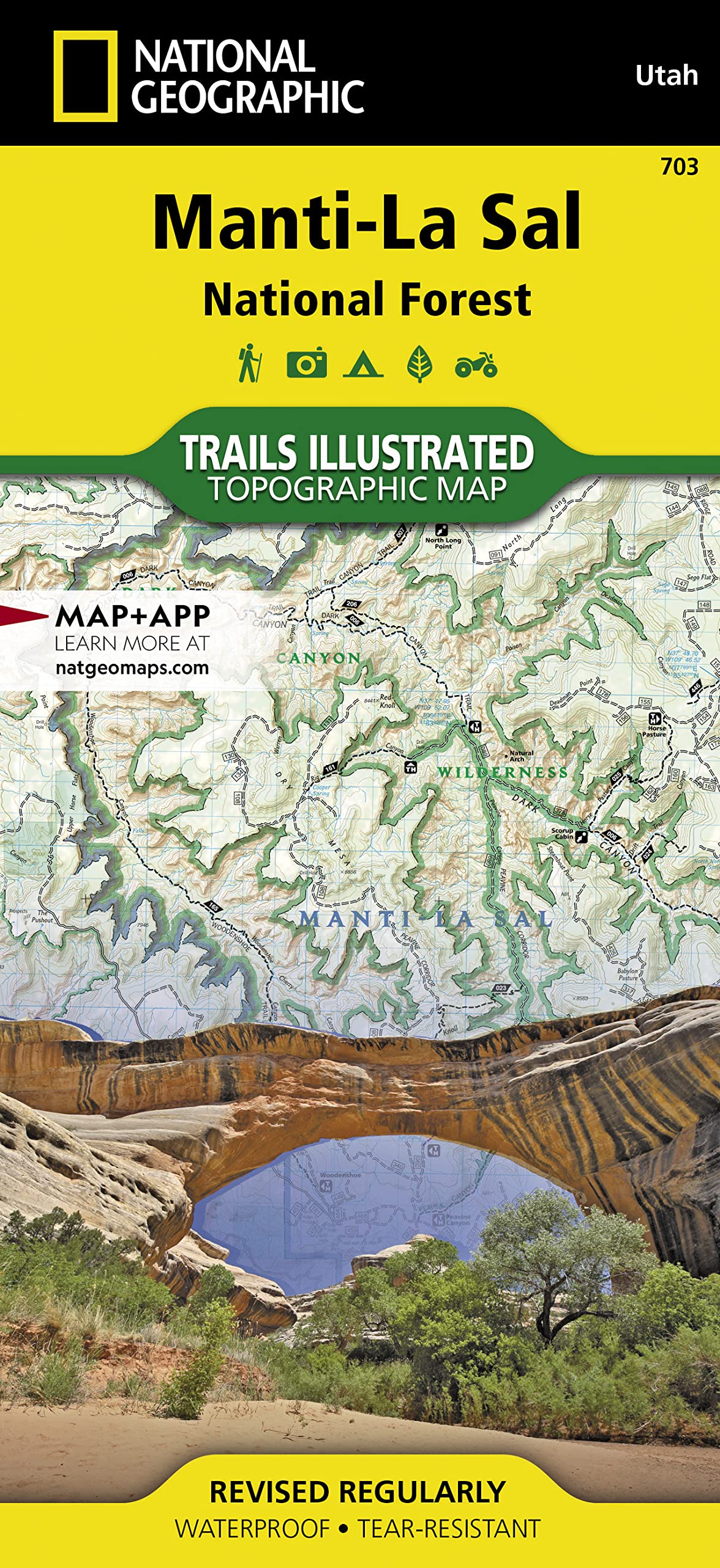
Waterproof Tearresistant Topographic Mapexpertly Researched And Created In Cooperation With The U.S. Forest Service, Bureau Of Land Management And Others, National Geographic'S Trails Illustrated Map Of Mantila Sal National Forest Provides Unmatched Detail Of The Discontiguous Moab And Monticello Ranger District Areas Of The Forest. The Map Covers Map Popular Points Of Interest, Including Dark Canyon Wilderness, Natural Bridges National Monument, Blue Mountains And Cheesebox Canyon.Outdoor Enthusiasts Will Be Able To Get Off The Beaten Track And Back On Again By Following The Map To Clearly Marked Trailheads And Then Along Precisely Mapped Trails, Labeled Either For Hiking, Motorcycle Or Atv Use, Including The Kokopelli Trail. Trails In The Moab Ranger District Also Have Mileage Indicators. To Assist In Your Navigation Of The Area, The Map Shows Contour Lines, Elevations, Labeled Peaks, Water Features, Selected Waypoints And Numbered Forest Service Roads. Recreation Features Include Areas For Camping, Boat Launching, Water Skiing And Fishing. The Unaweeptabeguache, Bicentennial And Trail Of The Ancients Scenic Byways Are Also All Marked.Every Trails Illustrated Map Is Printed On Backcountry Tough Waterproof, Tearresistant Paper. A Full Utm Grid Is Printed On The Map To Aid With Gps Navigation.Other Features Found On This Map Include: Abajo Mountains, Abajo Peak, Bears Ears, Canyonlands National Park, Dark Canyon Wilderness, Glen Canyon National Recreation Area, Grand Gulch Plateau, La Sal Mountains, Mantila Sal National Forest, Mount Peale, Paradox Valley. Map Scale = 1:70,000 Sheet Size = 37.75 X 25.5 Folded Size = 4.25 X 9.25
⚠️ WARNING (California Proposition 65):
This product may contain chemicals known to the State of California to cause cancer, birth defects, or other reproductive harm.
For more information, please visit www.P65Warnings.ca.gov.
- Q: What are the dimensions of the Manti-La Sal National Forest Map? A: The map measures thirty-seven point seventy-five inches by twenty-five point five inches when unfolded and four point twenty-five inches by nine point twenty-five inches when folded.
- Q: What type of paper is the Manti-La Sal National Forest Map made from? A: This map is printed on 'Backcountry Tough' waterproof and tear-resistant paper, ensuring durability in outdoor conditions.
- Q: How many pages does the Manti-La Sal National Forest Map have? A: The map contains two pages, providing detailed information about the area.
- Q: How do I use the Manti-La Sal National Forest Map for navigation? A: To use the map, locate your position using the UTM grid and follow the clearly marked trails and waypoints for hiking or ATV use.
- Q: Is the Manti-La Sal National Forest Map suitable for beginners? A: Yes, the map is suitable for beginners as it includes marked trailheads and labeled trails that are easy to follow.
- Q: Can I take the Manti-La Sal National Forest Map on a wet hike? A: Yes, the map is waterproof, making it suitable for use in wet conditions.
- Q: How should I store the Manti-La Sal National Forest Map when not in use? A: Store the map in a cool, dry place, ideally folded or in a protective sleeve to prevent damage.
- Q: What safety features does the Manti-La Sal National Forest Map include? A: The map includes contour lines, elevations, and numbered Forest Service roads to assist with safe navigation in the area.
- Q: How do I clean the Manti-La Sal National Forest Map? A: To clean the map, simply wipe it with a damp cloth; avoid using harsh chemicals that may damage the paper.
- Q: Is the Manti-La Sal National Forest Map suitable for GPS navigation? A: Yes, the map includes a full UTM grid that aids in GPS navigation for outdoor activities.
- Q: What popular points of interest are highlighted on the Manti-La Sal National Forest Map? A: The map highlights points of interest such as Dark Canyon Wilderness, Natural Bridges National Monument, and the Kokopelli Trail.
- Q: Can the Manti-La Sal National Forest Map be used for off-roading? A: Yes, the map includes trails labeled for motorcycle and ATV use, making it suitable for off-roading activities.
- Q: What types of outdoor activities can I do with the Manti-La Sal National Forest Map? A: You can use the map for hiking, camping, fishing, and navigating scenic byways like the Unaweep-Tabeguache.
- Q: What should I do if the Manti-La Sal National Forest Map arrives damaged? A: If the map arrives damaged, contact the seller for information on their return policy and how to exchange it.
- Q: Are there any hazards to be aware of while using the Manti-La Sal National Forest Map? A: While using the map, be aware of natural hazards such as steep terrain and weather changes in the forest.
- Q: Where can I purchase the Manti-La Sal National Forest Map? A: The Manti-La Sal National Forest Map can be purchased from outdoor retailers or directly from the National Geographic website.