
Title
National Geographic Antarctica Satellite Wall Map (31.25 X 20.25 In) (National Geographic Reference Map),New
Sold by Ergodebooks, an authorized reseller.
Returns accepted within 30 days | support@ergodebooks.com
Shipping Information
- Free Standard Shipping — United States only
- Processing Time: 3–5 business days
- Estimated Delivery: 6–10 business days after dispatch
- Double-boxed, fully insured & discreetly packaged
- Tracking number sent via email once dispatched
Returns & Refund
Returns accepted within 30 days of delivery.
Damaged or Defective Item
Free return shipping + replacement or full refund
Wrong Item Received
Free return shipping + replacement or full refund
Change of Mind
Return shipping at customer's expense · 25% restocking fee applies
Payment Option

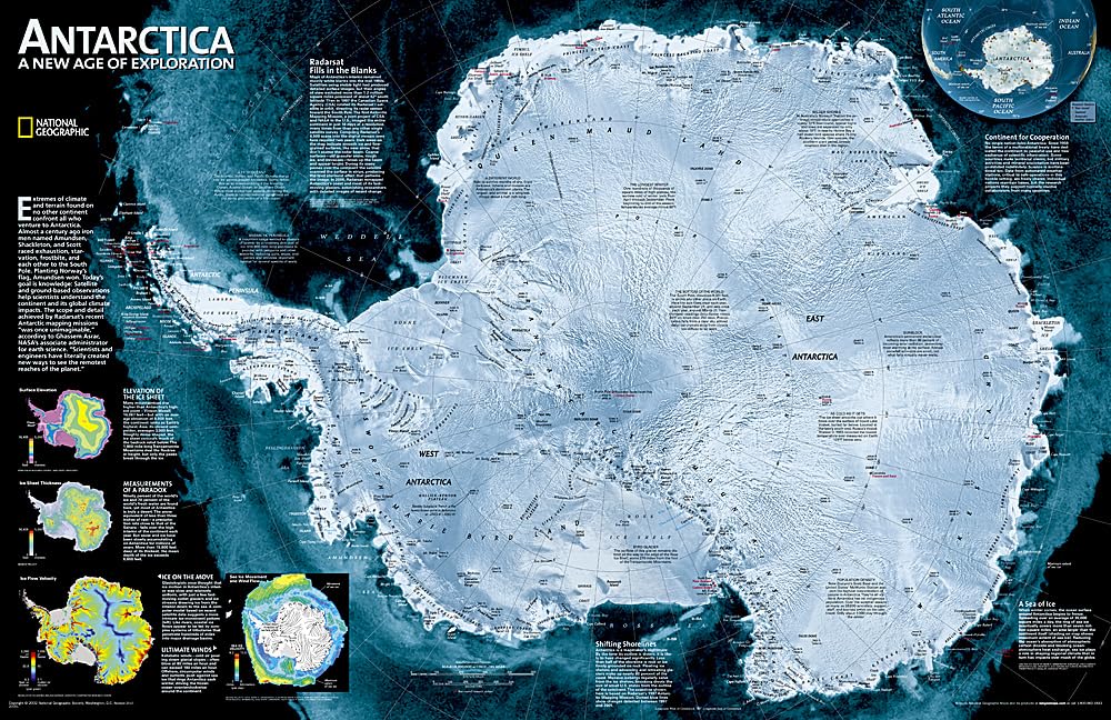
A Striking View Of Antarctica'S Terrain, Compiled From 4,500 Satellite Scans. Additional Inset Maps Show Surface Elevation, Ice Sheet Thickness, Velocity Of Ice Flow, And Sea Ice Movement And Windflow.The Map Is Packaged In A Two Inch Diameter Tube With A Label Showing A Thumbnail Of The Map With Dimensions And Other Pertinent Information. Map Scale = 1:9,200,000 Sheet Size = 31.25' X 20.25'
⚠️ WARNING (California Proposition 65):
This product may contain chemicals known to the State of California to cause cancer, birth defects, or other reproductive harm.
For more information, please visit www.P65Warnings.ca.gov.
- Q: What are the dimensions of the National Geographic Antarctica Satellite Wall Map? A: The map measures thirty-one point twenty-five inches by twenty point twenty-five inches. It's designed to provide a detailed view of Antarctica's terrain.
- Q: What is the scale of the Antarctica Satellite Wall Map? A: The map scale is one to nine million two hundred thousand. This scale allows for a comprehensive view of the continent's features.
- Q: How is the National Geographic Antarctica map packaged? A: The map is packaged in a two-inch diameter tube. This keeps it safe and easy to store or transport.
- Q: What information does the Antarctica map provide? A: The map shows surface elevation, ice sheet thickness, ice flow velocity, and sea ice movement. It’s an essential resource for understanding Antarctica's geography.
- Q: How do I display the National Geographic Antarctica map? A: You can frame it or hang it directly on a wall. Ensure it’s in a location where it can be easily viewed and appreciated.
- Q: Is the Antarctica Satellite Wall Map suitable for educational purposes? A: Yes, it's an excellent educational tool for geography and environmental studies. The detailed visuals help in teaching about climate and geography.
- Q: How do I clean the Antarctica map if it gets dirty? A: Use a soft, dry cloth to gently wipe the surface. Avoid using any liquid cleaners as they may damage the map.
- Q: Can I roll the map up for storage? A: Yes, you can roll it back up for storage. Just ensure it's rolled loosely to avoid creasing.
- Q: Is the Antarctica map made of durable material? A: Yes, the map is printed on high-quality paper designed for durability. It can withstand handling and occasional display.
- Q: What if my map arrives damaged? A: If your map arrives damaged, contact customer service for support. They will assist you with returns or exchanges.
- Q: Does the National Geographic Antarctica map come with a warranty? A: No, this product does not come with a warranty. However, customer satisfaction is prioritized, and support is available.
- Q: What age group is the Antarctica Satellite Wall Map suitable for? A: It is suitable for all ages, especially for students and adults interested in geography. Its educational value makes it a great learning resource.
- Q: How can I hang the Antarctica map on my wall? A: You can use adhesive strips, push pins, or a frame to hang it. Make sure it's securely attached to avoid falling.
- Q: Is the Antarctica Satellite Wall Map safe for children? A: Yes, the map is safe for children. However, adult supervision is recommended when handling it.
- Q: What makes the National Geographic Antarctica map unique? A: Its compilation from four thousand five hundred satellite scans offers a strikingly detailed view of Antarctica. This level of detail is rare in typical maps.