
Title
National Geographic Antarctica Satellite Wall Map (31.25 x 20.25 in) (National Geographic Reference Map),Used
Sold by Ergodebooks, an authorized reseller.
Returns accepted within 30 days | support@ergodebooks.com
Shipping Information
- Free Standard Shipping — United States only
- Processing Time: 3–5 business days
- Estimated Delivery: 6–10 business days after dispatch
- Double-boxed, fully insured & discreetly packaged
- Tracking number sent via email once dispatched
Returns & Refund
Returns accepted within 30 days of delivery.
Damaged or Defective Item
Free return shipping + replacement or full refund
Wrong Item Received
Free return shipping + replacement or full refund
Change of Mind
Return shipping at customer's expense · 25% restocking fee applies
Payment Option

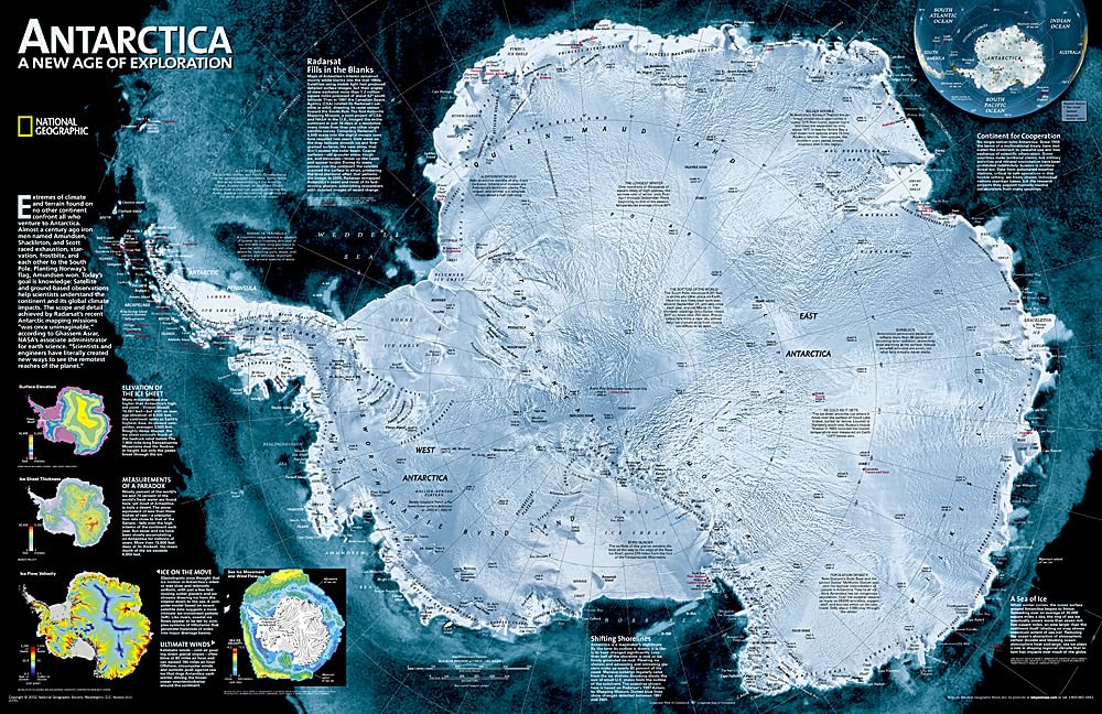
A striking view of Antarctica's terrain, compiled from 4,500 satellite scans. Additional inset maps show surface elevation, ice sheet thickness, velocity of ice flow, and sea ice movement and windflow.The map is packaged in a two inch diameter tube with a label showing a thumbnail of the map with dimensions and other pertinent information. Map Scale = 1:9,200,000 Sheet Size = 31.25' x 20.25'
⚠️ WARNING (California Proposition 65):
This product may contain chemicals known to the State of California to cause cancer, birth defects, or other reproductive harm.
For more information, please visit www.P65Warnings.ca.gov.
- Q: What are the dimensions of the National Geographic Antarctica Satellite Wall Map? A: The dimensions of the National Geographic Antarctica Satellite Wall Map are 31.25 inches by 20.25 inches.
- Q: What is the scale of the Antarctica Satellite Wall Map? A: The scale of the Antarctica Satellite Wall Map is 1:9,200,000.
- Q: What features are included in the map? A: The map includes detailed views of Antarctica's terrain, along with inset maps showing surface elevation, ice sheet thickness, velocity of ice flow, and sea ice movement and windflow.
- Q: How is the map packaged? A: The map is packaged in a two-inch diameter tube that includes a label displaying a thumbnail of the map with its dimensions and other relevant information.
- Q: Who is the author of the Antarctica Satellite Wall Map? A: The author of the Antarctica Satellite Wall Map is National Geographic Maps.
- Q: When was the Antarctica Satellite Wall Map published? A: The Antarctica Satellite Wall Map was published on October 13, 2015.
- Q: What type of product is this map classified as? A: This product is classified as a map.
- Q: What are the uses of the Antarctica Satellite Wall Map? A: The Antarctica Satellite Wall Map can be used for educational purposes, as a decorative item, or for geographical reference.
- Q: Is the Antarctica Satellite Wall Map suitable for framing? A: Yes, the map is suitable for framing, given its size and quality.
- Q: Can I find information about ice flow and elevation on this map? A: Yes, the map provides information about ice flow velocity and surface elevation through its additional inset maps.