
Title
National Geographic Wall Map - Britain and Ireland - Laminated - 23.5 x 30.25 in - Colorful Design
Sold by Ergodebooks, an authorized reseller.
Returns accepted within 30 days | support@ergodebooks.com
Shipping Information
- Free Standard Shipping — United States only
- Processing Time: 3–5 business days
- Estimated Delivery: 6–10 business days after dispatch
- Double-boxed, fully insured & discreetly packaged
- Tracking number sent via email once dispatched
Returns & Refund
Returns accepted within 30 days of delivery.
Damaged or Defective Item
Free return shipping + replacement or full refund
Wrong Item Received
Free return shipping + replacement or full refund
Change of Mind
Return shipping at customer's expense · 25% restocking fee applies
Payment Option

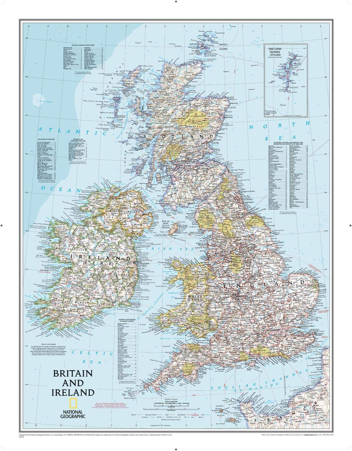
Discover the intricacies of Britain and Ireland with National Geographic's Classic political map. This map serves as both a stunning decorative piece for your study or classroom and an essential tool for anyone looking to explore the geographical and cultural landscape of these captivating countries.
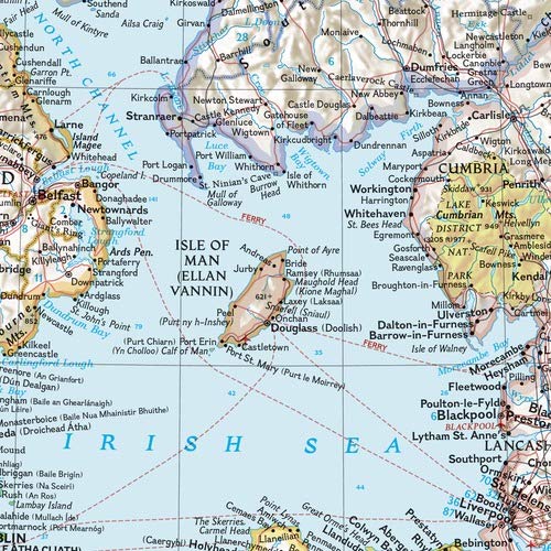
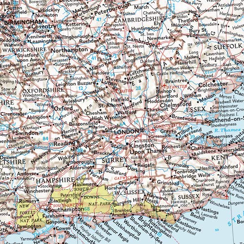
The National Geographic map features a wealth of detailed information, including thousands of place names, major highways, roads, airports, ferry routes, and various bodies of water. The map's handy indexes simplify the identification of counties, districts, council areas, unitary authorities, and metropolitan districts across Ireland, Northern Ireland, Scotland, Wales, and England. An inset map highlights the details of the Shetland Islands, ensuring comprehensive geographical understanding.
Designed for durability, this map is encapsulated in a heavy-duty 1.6 mil laminate, making it resistant to the effects of humidity. This lamination allows for easy framing without glass, resulting in lighter and more cost-effective displays. The map is rendered at a scale of 1:1,679,000, with an overall sheet size of 23.5" x 30.25".
Key Features:- Detailed political map of Britain and Ireland with thousands of place names.
- Major highways, roads, airports, and ferry routes clearly marked for easy navigation.
- Handy indexes for identifying counties, districts, and metropolitan areas.
- Inset map providing detailed information on the Shetland Islands.
- Heavy-duty 1.6 mil laminated finish for enhanced durability.
- Framable design without the need for glass, making it lighter and more affordable.
- Map scale of 1:1,679,000 for accurate representation.
This political map is ideal for educators, students, travelers, and anyone interested in the geography of Britain and Ireland. Its combination of aesthetic appeal and practical features makes it a valuable addition to any space, fostering a deeper understanding of these historic nations. Enhance your knowledge and appreciation of Britain's and Ireland's rich landscapes with this essential map.
⚠️ WARNING (California Proposition 65):
This product may contain chemicals known to the State of California to cause cancer, birth defects, or other reproductive harm.
For more information, please visit www.P65Warnings.ca.gov.
- Q: What are the dimensions of the National Geographic Britain and Ireland Wall Map? A: The dimensions are twenty-three point five inches by thirty point twenty-five inches. This size makes it ideal for display in classrooms or studies.
- Q: What is the scale of the map? A: The scale of the map is one to one million six hundred seventy-nine thousand. This provides a detailed view of the political boundaries and features.
- Q: Is this map laminated? A: Yes, the map is encapsulated in heavy-duty one point six mil laminate. This makes it durable and resistant to humidity changes.
- Q: How do I use this wall map? A: You can use this wall map for educational purposes, planning trips, or decorative displays. It's suitable for classrooms, offices, or home use.
- Q: Is this map suitable for framing? A: Yes, the laminated design allows for easy framing without glass. This keeps the frame lighter and more affordable.
- Q: What features are included on the map? A: The map includes thousands of place names, highways, airports, ferry routes, and bodies of water. It also highlights national parks and counties.
- Q: How should I clean the laminated map? A: You can clean it with a damp cloth to remove dust and stains. Avoid using harsh chemicals to preserve the laminate.
- Q: Can I store this map rolled up? A: Yes, you can store the map rolled up. However, for best results, keep it flat to maintain its shape.
- Q: What if my map arrives damaged? A: If your map arrives damaged, you can contact customer support for a replacement or refund. Keep the packaging for reference.
- Q: Is this map safe for children? A: Yes, the map is made of durable materials and is safe for children. It's an educational tool suitable for all ages.
- Q: What languages are featured on the map? A: The map features place names in both English and Gaelic (Irish). This reflects the official status of both languages in Ireland.
- Q: Where can I find details about specific regions on the map? A: Details about specific regions, including counties and districts, are provided in handy indexes on the map.
- Q: Is this map suitable for outdoor use? A: While the map is laminated for durability, it is primarily designed for indoor use. Prolonged exposure to outdoor elements may damage it.
- Q: Can I use this map for educational purposes? A: Yes, this map is an excellent resource for educational purposes, providing geographical information and historical context.
- Q: What is the manufacturer of this map? A: The map is manufactured by the National Geographic Society Maps, known for producing high-quality geographical materials.
- Q: Does the map show national parks? A: Yes, national parks are clearly indicated in green vignettes on the map. This helps identify important natural areas.