
Title
National Geographic Caribbean Wall Map - Classic Poster, 36 x 24 in, Blue Ocean
Sold by Ergodebooks, an authorized reseller.
Returns accepted within 30 days | support@ergodebooks.com
Shipping Information
- Free Standard Shipping — United States only
- Processing Time: 3–5 business days
- Estimated Delivery: 6–10 business days after dispatch
- Double-boxed, fully insured & discreetly packaged
- Tracking number sent via email once dispatched
Returns & Refund
Returns accepted within 30 days of delivery.
Damaged or Defective Item
Free return shipping + replacement or full refund
Wrong Item Received
Free return shipping + replacement or full refund
Change of Mind
Return shipping at customer's expense · 25% restocking fee applies
Payment Option

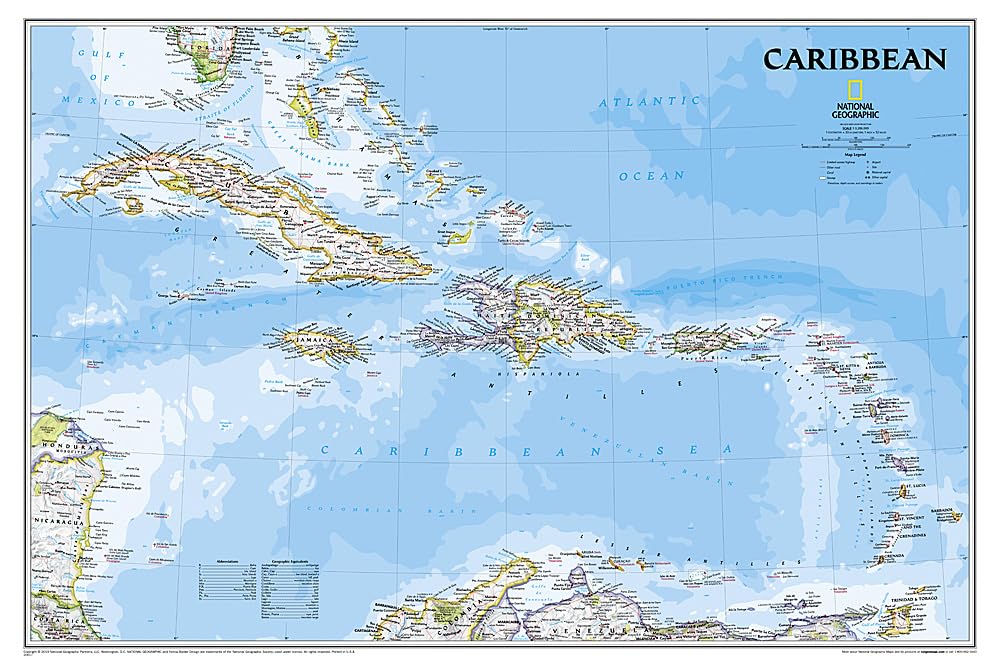
Discover the beauty and intricacies of the Caribbean Sea with this authoritative map from the National Geographic Society. Ideal for educators, travelers, and geography enthusiasts, this map serves as both a functional navigation tool and a decorative piece for any space.
This detailed map provides extensive coverage of the Caribbean region, stretching from the tip of Florida to the northern reaches of Colombia and Venezuela, and extending east to Barbados and west to the eastern edges of Honduras, Costa Rica, and Nicaragua. The design features remarkable bathymetric details, showcasing the unique seafloor variations, including the Puerto Rico Trench— the deepest point in the Atlantic Ocean at 8,605 meters (28,232 feet). The map is packaged in a convenient two-inch diameter tube, complete with a label that displays a thumbnail image of the map along with its dimensions and other pertinent information. With a scale of 1:3,286,000 and sheet size of 36" x 24", this map is both practical and visually striking.
Key Features:- Authoritative map of the Caribbean Sea, ideal for educational and decorative purposes.
- Extensive coverage from Florida to northern Colombia and Venezuela, including key islands.
- Detailed bathymetry reveals unique underwater topography, including the Puerto Rico Trench.
- Features over 1,000 named locations, including capitals, towns, and important landforms.
- Informative historical and geographical notes enhance understanding of the region.
- Packaged in a durable tube for easy storage and handling.
- Map scale of 1:3,286,000; sheet size measures 36" x 24" for clear visibility.
This detailed Caribbean map is perfect for teachers, students, and travelers seeking to deepen their understanding of the region. Whether used in a classroom, office, or home, it offers valuable insights into the geography and history of the Caribbean, making it an essential resource for anyone interested in this vibrant area of the world.
⚠️ WARNING (California Proposition 65):
This product may contain chemicals known to the State of California to cause cancer, birth defects, or other reproductive harm.
For more information, please visit www.P65Warnings.ca.gov.
- Q: What are the dimensions of the National Geographic Caribbean Wall Map? A: The map measures thirty-six inches by twenty-four inches. This poster size provides a detailed view of the Caribbean region.
- Q: What is the scale of the Caribbean Wall Map? A: The scale is one to three million two hundred eighty-six thousand. This allows for a comprehensive overview of the Caribbean islands.
- Q: Who is the author of this map? A: The author is National Geographic Maps. They are known for their authoritative and detailed cartographic representations.
- Q: How do I display the Caribbean Wall Map? A: You can display the map by framing it or using poster putty. It comes rolled in a tube for easy handling and mounting.
- Q: Is this map suitable for educational purposes? A: Yes, the map is highly suitable for educational use. It includes historical notes and geographical information about the Caribbean.
- Q: What type of binding does the National Geographic Caribbean Wall Map have? A: The binding is classified as a map. It is designed for durability and ease of use.
- Q: How should I store the Caribbean Wall Map? A: Store the map in a cool, dry place, preferably rolled in its tube. Avoid exposure to direct sunlight to prevent fading.
- Q: Can I clean the Caribbean Wall Map? A: No, cleaning is not recommended for this map. Instead, keep it dust-free by gently wiping with a dry cloth.
- Q: Is this map safe for children? A: Yes, the map is safe for children. It contains no hazardous materials and serves as an educational tool.
- Q: Can I return the National Geographic Caribbean Wall Map if I am not satisfied? A: Yes, you can return the map if you are not satisfied. Ensure it is in its original condition for a full refund.
- Q: What if the map arrives damaged? A: If the map arrives damaged, contact customer service immediately. They will assist you with a replacement or refund.
- Q: Is this map easy to read? A: Yes, the map is designed for clarity and ease of reading. It features detailed bathymetry and named locations.
- Q: What areas does the Caribbean Wall Map cover? A: The map covers the entire Caribbean region, extending from Florida to Colombia and Venezuela, including key islands.
- Q: Does this map include political boundaries? A: Yes, it includes political boundaries and important infrastructure. This provides a comprehensive view of the Caribbean.
- Q: What color is the Caribbean Wall Map? A: The map features a blue ocean color scheme. This enhances the visual representation of the Caribbean Sea.
- Q: Is the Caribbean Wall Map suitable for a gift? A: Yes, the map makes an excellent gift for geography enthusiasts or anyone interested in the Caribbean.