
Title
Natl Geographic Europe Classic Enlarged Wall Map - 46 x 35.75 inches, Reference Map
Sold by Ergodebooks, an authorized reseller.
Returns accepted within 30 days | support@ergodebooks.com
Shipping Information
- Free Standard Shipping — United States only
- Processing Time: 3–5 business days
- Estimated Delivery: 6–10 business days after dispatch
- Double-boxed, fully insured & discreetly packaged
- Tracking number sent via email once dispatched
Returns & Refund
Returns accepted within 30 days of delivery.
Damaged or Defective Item
Free return shipping + replacement or full refund
Wrong Item Received
Free return shipping + replacement or full refund
Change of Mind
Return shipping at customer's expense · 25% restocking fee applies
Payment Option

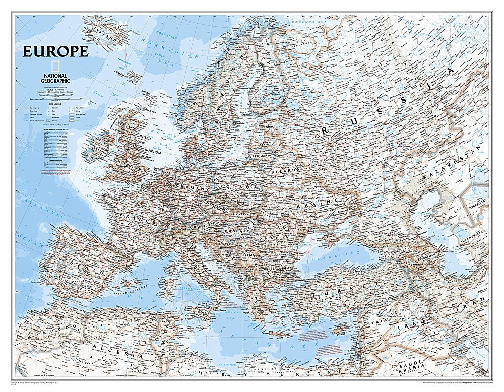
The National Geographic Europe Wall Map is a meticulously crafted reference map that serves as an essential resource for education, travel planning, and home decor. Its detailed design and vibrant colors make it an excellent addition to both personal and professional spaces.
This wall map showcases Europe with a focus on accuracy and clarity. Printed on high-quality paper, the map features a bright and easy-to-read color palette, highlighting blue oceans and colorful borders. The background is designed with subtle shaded relief to depict mountain ranges and valleys, providing a three-dimensional feel. This map is ideal for educators, travelers, and anyone interested in the geography of Europe.
Key Features:- Authoritative Design: The Europe Wall Map is created by National Geographic, a trusted name in cartography, ensuring high accuracy and reliability.
- Detailed Cartography: Major water bodies, including rivers, lakes, and seas, are clearly marked, along with thousands of place names for easy navigation.
- Up-to-Date Boundaries: The map reflects current international boundaries and territorial control, ensuring users have the most relevant information.
- Comprehensive Coverage: Countries displayed include Albania, Austria, Germany, and the United Kingdom, among others, providing a complete view of Europe.
- Immersive Experience: Enlarged sheet size of 46" x 35.75" enhances visibility, making it suitable for both home and office environments.
- Convenient Packaging: The map is delivered in a durable two-inch diameter tube, featuring a label with essential information and a thumbnail image.
- Map Scale: The scale of 1:5,419,000 allows for detailed exploration of both urban and rural areas across Europe.
The National Geographic Europe Wall Map is perfect for educators seeking to enhance classroom learning, travelers planning their next adventure, or anyone looking to elevate their home or office decor with a stunning geographical representation. Its detailed features and accurate information make it an invaluable tool for understanding European geography.
⚠️ WARNING (California Proposition 65):
This product may contain chemicals known to the State of California to cause cancer, birth defects, or other reproductive harm.
For more information, please visit www.P65Warnings.ca.gov.
- Q: What are the dimensions of the National Geographic Europe Wall Map? A: The dimensions of the map are forty-six inches by thirty-five point seventy-five inches. This enlarged size provides a detailed view of Europe, making it suitable for both home and office display.
- Q: What is the scale of the National Geographic Europe Wall Map? A: The scale of the map is one to five million four hundred nineteen thousand. This scale allows for an accurate representation of geographical features and boundaries.
- Q: What materials are used in the National Geographic Europe Wall Map? A: The map is printed on high-quality paper designed for durability. It is packaged in a two-inch diameter tube for easy storage and transport.
- Q: How do I display the National Geographic Europe Wall Map? A: You can display the map by framing it or using adhesive strips for wall mounting. The larger size makes it a focal point in any room.
- Q: Is the map suitable for educational purposes? A: Yes, the map is highly suitable for educational settings. It features detailed geographical information that can aid in geography lessons and discussions.
- Q: What should I consider when hanging the National Geographic Europe Wall Map? A: Consider the wall space available and ensure it is well-lit for visibility. A flat, stable surface is best for hanging to avoid warping.
- Q: How should I care for my National Geographic Europe Wall Map? A: To care for the map, avoid direct sunlight to prevent fading. Clean it gently with a soft cloth to remove dust or fingerprints.
- Q: Can I roll up the National Geographic Europe Wall Map for storage? A: Yes, you can roll it up for storage. Just ensure it is rolled loosely to avoid creasing and store it in a cool, dry place.
- Q: Does the National Geographic Europe Wall Map contain outdated information? A: No, the map reflects up-to-date international boundaries and territorial control based on current authoritative sources. It is meticulously researched for accuracy.
- Q: Is the map appropriate for children? A: Yes, the map is appropriate for children, especially for educational purposes. It can help them learn about geography and world cultures.
- Q: How can I tell if the map is authentic? A: You can verify authenticity by checking the branding and packaging, which should indicate it is produced by National Geographic Society Maps.
- Q: What features are highlighted on the National Geographic Europe Wall Map? A: The map highlights major water bodies, cities, international borders, and physical features like mountain ranges and valleys, all in a clear, colorful design.
- Q: What is the best way to transport the map? A: The best way to transport the map is rolled in its original tube, which protects it from damage during transit.
- Q: Are there any specific regions not covered on the map? A: No, the map covers all European countries, including Albania, Austria, Germany, and the United Kingdom, ensuring comprehensive geographical coverage.
- Q: What is the binding type of the National Geographic Europe Wall Map? A: The map is bound as a rolled map, which is ideal for display and storage without damaging the material.