
Title
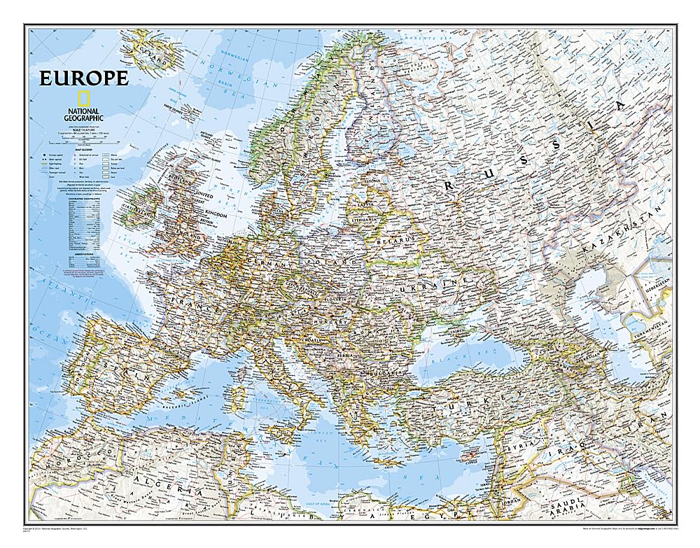
National Geographic Europe Classic Wall Map - 30.5 x 23.75 inches - Full Color
Sold by Ergodebooks, an authorized reseller.
Returns accepted within 30 days | support@ergodebooks.com
Shipping Information
- Free Standard Shipping — United States only
- Processing Time: 3–5 business days
- Estimated Delivery: 6–10 business days after dispatch
- Double-boxed, fully insured & discreetly packaged
- Tracking number sent via email once dispatched
Returns & Refund
Returns accepted within 30 days of delivery.
Damaged or Defective Item
Free return shipping + replacement or full refund
Wrong Item Received
Free return shipping + replacement or full refund
Change of Mind
Return shipping at customer's expense · 25% restocking fee applies
Payment Option

The National Geographic classic political map of Europe is an essential tool for educators, travelers, and geography enthusiasts. This detailed map provides an extensive overview of Europe’s geography, showcasing country boundaries, place names, and significant transportation routes.
This map is printed in full color, ensuring vibrant and clear visuals that enhance the viewing experience. With a scale size of 1:8,425,000, it provides an accurate representation of distances and locations across the continent. The map is tubed for easy storage and transportation, measuring 24 inches by 30 inches when displayed. Ideal for classrooms, offices, or personal study, this political map serves both practical and decorative purposes.
Key Features:- Detailed representation of country boundaries across Europe.
- Includes place names for major cities and geographical landmarks.
- Highlights significant bodies of water, enhancing geographical context.
- Displays airports and major highways for travel planning.
- Full-color printing for vibrant and engaging visuals.
- Tubed packaging for easy transport and storage.
- Scale size of 1:8,425,000 for accurate geographical reference.
This political map is perfect for teachers looking to enhance their geography lessons, travelers planning their next European adventure, or anyone interested in the intricate details of European geography. With its high-quality print and comprehensive features, the National Geographic map is a valuable addition to any collection. It not only serves educational purposes but also adds an aesthetic touch to any space, making it an ideal gift for geography lovers and students alike.
⚠️ WARNING (California Proposition 65):
This product may contain chemicals known to the State of California to cause cancer, birth defects, or other reproductive harm.
For more information, please visit www.P65Warnings.ca.gov.
- Q: What are the dimensions of the National Geographic Europe Classic Wall Map? A: The dimensions are thirty inches by twenty-three point seventy-five inches. This size is suitable for detailed viewing and wall display.
- Q: What is the scale of the Europe Classic Wall Map? A: The scale is one to eight million four hundred twenty-five thousand. This allows for a detailed representation of European geography.
- Q: What type of binding does the National Geographic map have? A: It has a map binding. This type of binding is designed for durability and ease of use.
- Q: How can I display the Europe Classic Wall Map? A: You can display it by framing it or hanging it directly on the wall. Tubed packaging makes it easy to transport and set up.
- Q: Is this map suitable for educational purposes? A: Yes, it is highly suitable for educational purposes. The detailed features enhance learning about European geography.
- Q: How do I clean the National Geographic Wall Map? A: You can clean it by gently wiping with a soft, dry cloth. Avoid using water or cleaning solutions to preserve the map's integrity.
- Q: How should I store the map if not displayed? A: You should store it rolled in its tube to prevent creasing or damage. Keep it in a cool, dry place away from direct sunlight.
- Q: Is the map safe for children? A: Yes, the map is safe for children. It does not contain hazardous materials, making it suitable for educational settings.
- Q: Can I use this map for travel planning? A: Yes, it is great for travel planning. The detailed roads, airports, and boundaries help in planning routes and destinations.
- Q: What features are included on the Europe Classic Wall Map? A: It includes country boundaries, place names, bodies of water, major highways, and airports. These features provide a comprehensive overview of Europe.
- Q: What materials is the map made from? A: The map is made from high-quality paper with a full-color print. This ensures vibrant visuals and durability.
- Q: Is this map suitable for a living room decoration? A: Yes, it is suitable for living room decoration. Its classic design and colors complement various interior styles.
- Q: What age group is this map appropriate for? A: It is appropriate for all age groups. Its educational value appeals to both children and adults.
- Q: Does the map include major highways and roads? A: Yes, it does include major highways and roads. This feature aids in navigation and route planning.
- Q: What publisher created the Europe Classic Wall Map? A: The map is published by National Geographic Maps. Known for quality, they provide reliable and accurate maps.
- Q: Can the map be used for wall art? A: Yes, it can be used as wall art. Its colorful and detailed design makes it visually appealing.