
Title
National Geographic Wall Map - France, Belgium, and The Netherlands - Laminated - 23.5 x 30.25 in - Model RE00620333
Sold by Ergodebooks, an authorized reseller.
Returns accepted within 30 days | support@ergodebooks.com
Shipping Information
- Free Standard Shipping — United States only
- Processing Time: 3–5 business days
- Estimated Delivery: 6–10 business days after dispatch
- Double-boxed, fully insured & discreetly packaged
- Tracking number sent via email once dispatched
Returns & Refund
Returns accepted within 30 days of delivery.
Damaged or Defective Item
Free return shipping + replacement or full refund
Wrong Item Received
Free return shipping + replacement or full refund
Change of Mind
Return shipping at customer's expense · 25% restocking fee applies
Payment Option

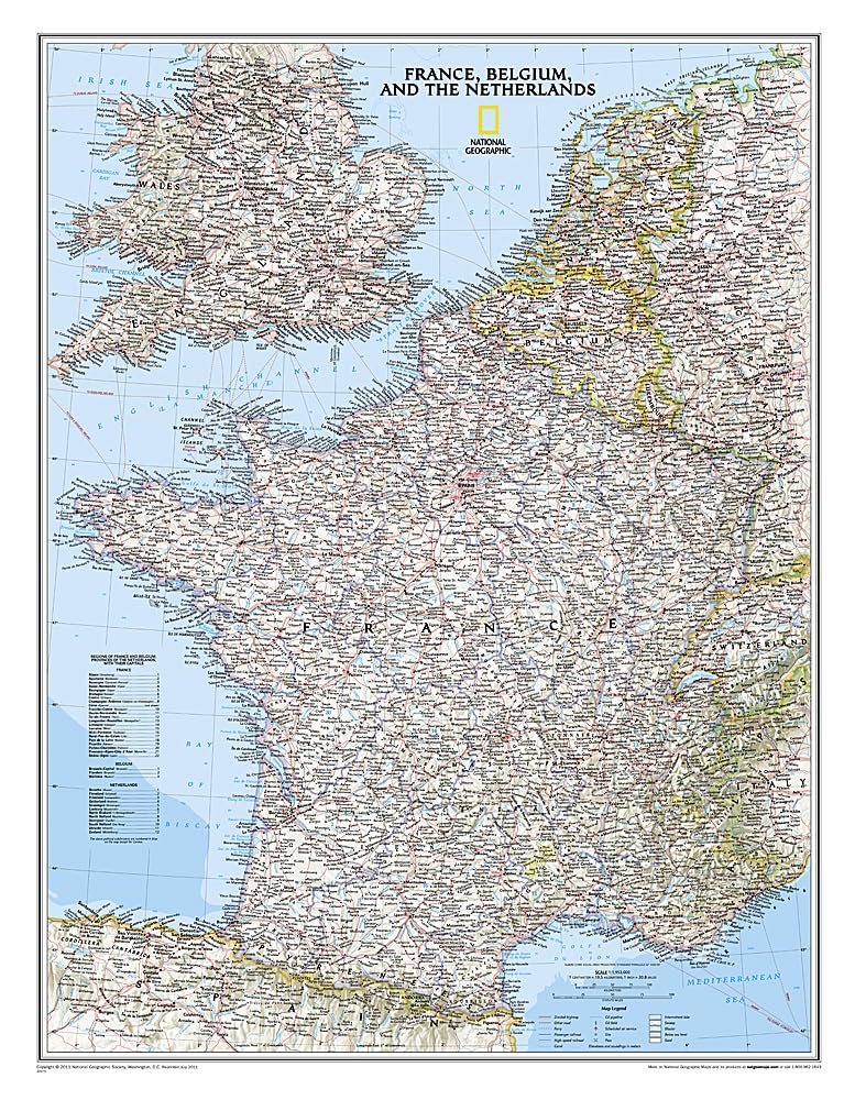
Explore the rich landscapes of France, Belgium, and The Netherlands with the National Geographic Classic style political map. This expertly crafted map is ideal for educators, students, travelers, and map enthusiasts seeking detailed geographical information.
This political map features meticulously researched and designed elements, showcasing clearly defined international boundaries, numerous place names, water bodies, airports, major highways, and roads. It also highlights national parks and other significant features. The map is designed with updated infrastructures in mind, including major oil fields, pipelines, high-speed passenger railway lines, canals, and ferry routes. The tasteful color palette, combined with shaded relief and bathymetric data, enhances both its aesthetic appeal and functionality. Portions of Luxembourg and the United Kingdom, Germany, Switzerland, Spain, and Italy are also represented for a comprehensive view of the region.
Key Features:- Durable Laminated Finish: The map is encapsulated in heavy-duty 1.6 mil laminate, ensuring long-lasting durability and resistance to humidity-related issues.
- Map Scale: This detailed map features a scale of 1:1,955,000, providing an accurate representation of the geography.
- Sheet Size: With dimensions of 23.5" x 30.25", the map is large enough for clear visibility while remaining easy to handle.
- Comprehensive Coverage: Includes extensive geographical details of France, Belgium, and The Netherlands, along with relevant portions of neighboring countries.
- Educational Resource: Perfect for classrooms or home study, this map serves as a practical educational tool for understanding European geography.
- Framable Design: The laminated finish allows for easy framing without glass, making it an economical and lightweight option for display.
- Visual Appeal: The attractive color palette and detailed relief features make this map not only functional but also a beautiful addition to any space.
This National Geographic Classic style political map is an excellent choice for anyone interested in geography, history, or travel. It is perfect for educational settings, personal use, and decorative display. Invest in this high-quality map to enhance your understanding and appreciation of the European landscape.
⚠️ WARNING (California Proposition 65):
This product may contain chemicals known to the State of California to cause cancer, birth defects, or other reproductive harm.
For more information, please visit www.P65Warnings.ca.gov.
- Q: What are the dimensions of the National Geographic Wall Map? A: The map measures twenty-three and a half inches by thirty and a quarter inches. This size makes it suitable for display in various settings.
- Q: What is the scale of the National Geographic Wall Map? A: The map scale is one to one million nine hundred fifty-five thousand. This scale provides detailed representations of the area.
- Q: What material is the National Geographic Wall Map made from? A: The map is encapsulated in heavy-duty laminate. This material enhances durability and resistance to humidity.
- Q: How do I hang the National Geographic Wall Map? A: You can hang the map using a frame without glass. This is possible due to its laminated finish, making it lighter.
- Q: Is the National Geographic Wall Map suitable for educational purposes? A: Yes, the map is ideal for educational use. It features clearly defined international boundaries and thousands of place names.
- Q: Can this map be used for navigation? A: No, this map is not intended for navigation. It is a political reference map designed for educational and decorative purposes.
- Q: How should I clean the National Geographic Wall Map? A: You should wipe the laminated surface with a soft, damp cloth. Avoid using abrasive materials to prevent damage.
- Q: Is the map safe to use in a child's room? A: Yes, the map is suitable for children's rooms. It features educational content without hazardous materials.
- Q: What is the best way to store the map if not displayed? A: Store the map flat in a dry place to prevent curling. Ensure it is kept away from moisture.
- Q: How does this map compare to others in the same category? A: This map features a unique classic design with detailed geopolitical information. It stands out for its educational and decorative value.
- Q: Is the National Geographic Wall Map suitable for professional use? A: Yes, the map is suitable for professional use. Its detailed features make it a valuable resource for geography-related work.
- Q: What if the map arrives damaged? A: If the map arrives damaged, contact customer support for a replacement. Ensure you report the issue within the return window.
- Q: Does this map include major transportation routes? A: Yes, the map includes major highways and railway lines. This information is useful for understanding regional connectivity.
- Q: Can I frame the map without glass? A: Yes, the laminate allows for framing without glass. This makes it a lightweight and cost-effective option.
- Q: Are there any specific care instructions for the map? A: Yes, avoid exposing the map to extreme temperatures or direct sunlight. This will help maintain its condition over time.
- Q: What regions does the map cover beyond France, Belgium, and The Netherlands? A: The map also shows parts of Luxembourg and portions of the United Kingdom, Germany, Switzerland, Spain, and Italy.