
Title


National Geographic Classic Wall Map - Middle East, Laminated, 30.25x23.5 inches, Blue, Model 20153
Sold by Ergodebooks, an authorized reseller.
Returns accepted within 30 days | support@ergodebooks.com
Shipping Information
- Free Standard Shipping — United States only
- Processing Time: 3–5 business days
- Estimated Delivery: 6–10 business days after dispatch
- Double-boxed, fully insured & discreetly packaged
- Tracking number sent via email once dispatched
Returns & Refund
Returns accepted within 30 days of delivery.
Damaged or Defective Item
Free return shipping + replacement or full refund
Wrong Item Received
Free return shipping + replacement or full refund
Change of Mind
Return shipping at customer's expense · 25% restocking fee applies
Payment Option

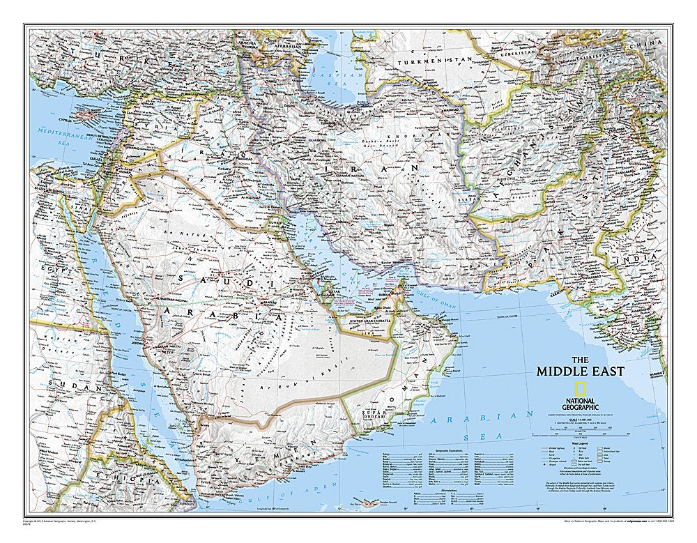
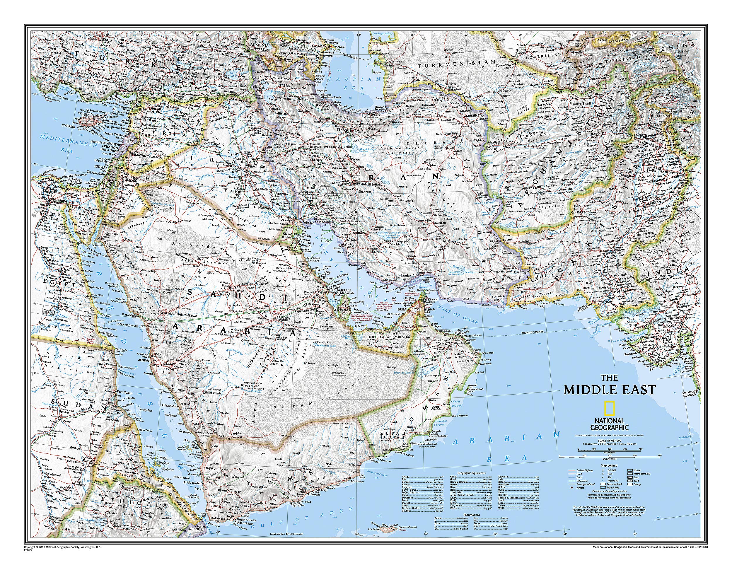
Explore the intricate geography of the Middle East with the National Geographic map, a comprehensive tool for travelers, educators, and geography enthusiasts. This expertly designed map offers a detailed view of a region that spans from northern Africa to the western edges of China and India, making it an essential resource for anyone interested in this historically rich area.
The National Geographic map of the Middle East is crafted with precision, showcasing an extensive range of countries, including complete coverage of Afghanistan, Pakistan, Iran, Iraq, Kuwait, and many more. It features thousands of place names, accurate political boundaries, and major infrastructure networks, including roads, airports, and railroads. The map's stunning shaded relief and coastal bathymetry convey the region's diverse terrain, while elevations and depth soundings are expressed in meters for clear understanding. The vibrant color palette enhances readability, making it an ideal reference for home, office, or educational settings.
Key Features:- Detailed political markings for clear navigation and understanding of geopolitical boundaries.
- Complete coverage of 18 countries, ensuring comprehensive geographical insights.
- Map Scale: 1 inch equals 96 miles, providing precise distance measurements.
- Map Dimensions: 23 inches high by 34 inches wide, making it suitable for various display options.
- Laminated finish for enhanced durability, resistant to humidity and wear.
- Easy to frame without glass, resulting in lighter and more affordable display solutions.
- Classic design that has been trusted for over 75 years, combining aesthetics with functionality.
This National Geographic map is perfect for educators looking to enrich their geography lessons, travelers planning their next adventure, or anyone seeking a decorative yet informative piece for their space. Its durability and quality make it a valuable addition to any collection, providing insights into the Middle East's complex geography for years to come.
⚠️ WARNING (California Proposition 65):
This product may contain chemicals known to the State of California to cause cancer, birth defects, or other reproductive harm.
For more information, please visit www.P65Warnings.ca.gov.
- Q: What is the size of the National Geographic Middle East Classic Wall Map? A: The map measures 30.25 inches in height and 23.5 inches in width.
- Q: Is the map laminated, and what does that mean for its durability? A: Yes, the map is encapsulated in heavy-duty 1.6 mil laminate, making it more durable and resistant to humidity changes, which helps prevent swelling and shrinking.
- Q: What regions are covered in this wall map? A: The map covers a broad area from northern Africa, through the Fertile Crescent, to parts of China and India, including complete coverage of 18 countries such as Iraq, Iran, Saudi Arabia, and Yemen.
- Q: Can this map be framed without glass? A: Yes, because it is laminated, the map can be framed without the need for glass, resulting in lighter and less expensive frames.
- Q: What features are highlighted on the map? A: The map features detailed political markings, thousands of place names, major infrastructure networks, archeological sites, and accurate shaded relief to depict diverse terrain.
- Q: What is the scale of the map? A: The map scale is 1:6,083,000, meaning that one inch on the map equates to 96 miles in real life.
- Q: Is this map suitable for educational purposes? A: Yes, the detailed political and geographic information makes it suitable for educational use, helping students and learners understand the Middle East region.
- Q: What material is used for the map, and is it suitable for display? A: The map is made of durable paper and laminated for added protection, making it suitable for display in homes, classrooms, or offices.
- Q: When was the National Geographic Middle East Classic Wall Map published? A: The map was published on September 21, 2018.
- Q: Who is the author of this wall map? A: The map is authored by National Geographic Maps - Reference.