
Title
National Geographic World Wall Map Classic Laminated (Poster Size: 36 X 24 In) (National Geographic Reference Map)
Sold by Ergodebooks, an authorized reseller.
Returns accepted within 30 days | support@ergodebooks.com
Shipping Information
- Free Standard Shipping — United States only
- Processing Time: 3–5 business days
- Estimated Delivery: 6–10 business days after dispatch
- Double-boxed, fully insured & discreetly packaged
- Tracking number sent via email once dispatched
Returns & Refund
Returns accepted within 30 days of delivery.
Damaged or Defective Item
Free return shipping + replacement or full refund
Wrong Item Received
Free return shipping + replacement or full refund
Change of Mind
Return shipping at customer's expense · 25% restocking fee applies
Payment Option

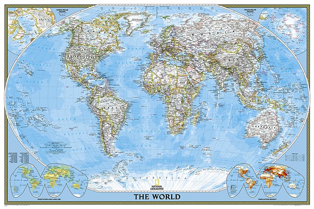
Expertly Researched And Designed, National Geographic'S World Wall Map Is The Authoritative Map Of The World By Which Other Reference Maps Are Measured.Product Features: Signature Classic Style Map With Bright, Easy To Read Color Palette With Blue Oceans And Colorful Borders Background Shows Mountain Ranges And Valleys In Subtle Shaded Relief With Mountain Ranges Labeled Major Water Bodies Including Rivers, Lakes, Glaciers, Oceans, Seas, Gulfs, Bays, Straits, And Bathymetry Clearly Defined International Boundaries, Cities, Islands, Airports, And Physical Features Thousands Of Place Names Carefully And Artfully Placed To Maintain Legibility In Heavily Populated Areas Uptodate International Boundaries And Territorial Control Reflect De Facto Status On The Ground Meticulously Researched Using Multiple Authoritative Sources Including The U.N., U.S. Board On Geographic Names, And Policies Of Individual Governments. Accurate Place Names Use A Combination Of Conventional English Names, Official National Names, And Standard Transliterations For Nonlatin Alphabets. Drawn In Winkel Tripel Projection With Distortions Minimized Unlike Other World Maps (E.G. Greenland Is Shown The Same Size As Argentina, Not South America) Corner Inset Maps Feature Vegetation, Land Use, Population Density, And North And South Polar Regionsthe 36 X 24 Poster Size Supports Easy And Affordable Framing And Mounting, And Takes Less Wall Space Than Standard Wall Maps.The Map Is Encapsulated In Heavyduty 1.6 Mil Laminate Which Makes The Paper Much More Durable And Resistant To The Swelling And Shrinking Caused By Changes In Humidity. Laminated Maps Can Be Framed Without The Need For Glass, So The Frames Can Be Much Lighter And Less Expensive. Map Scale = 1:37,213,000 Sheet Size = 36 X 24
⚠️ WARNING (California Proposition 65):
This product may contain chemicals known to the State of California to cause cancer, birth defects, or other reproductive harm.
For more information, please visit www.P65Warnings.ca.gov.
- Q: What are the dimensions of the National Geographic World Wall Map? A: The National Geographic World Wall Map is poster-sized, measuring 36 inches by 24 inches.
- Q: Is the map laminated? A: Yes, the map is encapsulated in heavy-duty 1.6 mil laminate, making it durable and resistant to humidity changes.
- Q: What features does the world map include? A: The map includes clearly defined international boundaries, cities, islands, airports, and physical features, along with thousands of place names.
- Q: What scale is the map drawn to? A: The map is drawn to a scale of 1:37,213,000.
- Q: Can the map be framed easily? A: Yes, the laminated design allows for easy framing without the need for glass, which makes the frames lighter and less expensive.
- Q: Who is the author of this wall map? A: The wall map is created by National Geographic Maps, known for their authoritative and well-researched cartography.
- Q: When was the National Geographic World Wall Map published? A: The map was published on November 29, 2018.
- Q: What type of projection is used for the map? A: The map is drawn in Winkel Tripel projection, which minimizes distortions commonly found in other world maps.
- Q: What additional information does the map provide? A: Corner inset maps feature details on vegetation, land use, population density, and the north and south polar regions.
- Q: Is the map suitable for educational purposes? A: Yes, the map is expertly researched and designed, making it a valuable resource for educational settings.