
Title
Patagonia South Icefield Trekking Mountaineering (Spanish and English Edition),Used
Sold by Ergodebooks, an authorized reseller.
Returns accepted within 30 days | support@ergodebooks.com
Shipping Information
- Free Standard Shipping — United States only
- Processing Time: 3–5 business days
- Estimated Delivery: 6–10 business days after dispatch
- Double-boxed, fully insured & discreetly packaged
- Tracking number sent via email once dispatched
Returns & Refund
Returns accepted within 30 days of delivery.
Damaged or Defective Item
Free return shipping + replacement or full refund
Wrong Item Received
Free return shipping + replacement or full refund
Change of Mind
Return shipping at customer's expense · 25% restocking fee applies
Payment Option

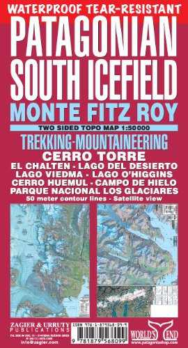
PATAGONIAN SOUTH ICEFIELD TEARRESISTANT MAP 1:50.000 Trekking and mountaineering map for the area of Monte Fitz Roy, Cerro Torre, El Chalten and the Southern Icecap in Patagonia (Argentina/Chile). Satellite relief, contour lines, GPS waypoints, campsites, walking times, popular and exploring routes, etc. From Lago O'Higgins to Lago Viedma printed both sides on a 70 x 100 cm sheet. The most important map covering this area.2019 edition printed on tearresistant waterproof recycled plastic paper.
⚠️ WARNING (California Proposition 65):
This product may contain chemicals known to the State of California to cause cancer, birth defects, or other reproductive harm.
For more information, please visit www.P65Warnings.ca.gov.
- Q: What are the dimensions of the Patagonia South Icefield map? A: The map measures seventy by one hundred centimeters. It is designed to be easily portable for trekking and mountaineering.
- Q: What material is the Patagonia South Icefield map made from? A: The map is printed on tear-resistant waterproof recycled plastic paper. This ensures durability and longevity in outdoor conditions.
- Q: How many pages does the Patagonia South Icefield map have? A: The map consists of two pages. It provides detailed information for trekkers and mountaineers in the region.
- Q: How do I use the Patagonia South Icefield map? A: Simply unfold the map to access detailed trekking and mountaineering routes. It includes GPS waypoints and campsites for navigation.
- Q: Is the Patagonia South Icefield map suitable for beginners? A: Yes, the map is suitable for both beginners and experienced trekkers. It provides clear routes and essential information for navigation.
- Q: Can I use the Patagonia South Icefield map for outdoor activities? A: Yes, the map is specifically designed for trekking and mountaineering. It covers popular routes in the Southern Icecap area.
- Q: How do I maintain the Patagonia South Icefield map? A: To keep the map in good condition, store it flat and avoid exposing it to extreme heat. Clean with a damp cloth if necessary.
- Q: Is the Patagonia South Icefield map waterproof? A: Yes, the map is waterproof. Its material makes it resistant to water damage, ideal for outdoor use in various weather conditions.
- Q: What should I do if my Patagonia South Icefield map arrives damaged? A: If the map arrives damaged, contact the seller for a replacement or return. Ensure to keep the original packaging for easier handling.
- Q: Is the Patagonia South Icefield map environmentally friendly? A: Yes, it is printed on recycled plastic paper. This eco-friendly choice helps reduce waste while providing a durable product.
- Q: Does the Patagonia South Icefield map include GPS waypoints? A: Yes, the map includes GPS waypoints. This feature helps trekkers navigate accurately in the rugged terrain of Patagonia.
- Q: Who is the author of the Patagonia South Icefield map? A: The map is authored by Sergio Zagier. He has expertise in the region, providing accurate and useful information.
- Q: Can I find campsites on the Patagonia South Icefield map? A: Yes, the map indicates various campsites. It is designed to assist trekkers in planning their routes and overnight stays.
- Q: What type of binding does the Patagonia South Icefield map have? A: The map has a binding type of 'map'. It is designed for easy unfolding and refolding during outdoor activities.
- Q: Is this map available in multiple languages? A: Yes, the Patagonia South Icefield map is available in both Spanish and English. This makes it accessible to a wider audience.