
Title
Patagonian & Fuegian Channels Waterproof Map: Chilean Fjords Cruise Chart Cape Horn, Ushuaia, Magellan Strait,New
Sold by Ergodebooks, an authorized reseller.
Returns accepted within 30 days | support@ergodebooks.com
Shipping Information
- Free Standard Shipping — United States only
- Processing Time: 3–5 business days
- Estimated Delivery: 6–10 business days after dispatch
- Double-boxed, fully insured & discreetly packaged
- Tracking number sent via email once dispatched
Returns & Refund
Returns accepted within 30 days of delivery.
Damaged or Defective Item
Free return shipping + replacement or full refund
Wrong Item Received
Free return shipping + replacement or full refund
Change of Mind
Return shipping at customer's expense · 25% restocking fee applies
Payment Option

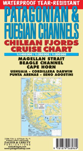
CHILEAN FJORDS WATERPROOF TEARRESISTANT CHART. Historical and hydrographical map. Highly improved new edition! Cruise log for the intrincate coast of the south of South America. Insets of Beagle Channel (Glaciers Avenue), Agostini Fjord, Wulaia Inlet and Romanche Bay.Carta hidrografica historica. Permite seguir el derrotero de los cruceros que recorren los fiordos chilenos en la intrincada costa del sur de Sudamerica. Ampliaciones del Seno Agostini, de la Avenida de los Glaciares del Canal Beagle, de la Caleta Wulaia y Bahia Romanche.Nueva edicion impresa en papel irrompible a prueba de agua.
⚠️ WARNING (California Proposition 65):
This product may contain chemicals known to the State of California to cause cancer, birth defects, or other reproductive harm.
For more information, please visit www.P65Warnings.ca.gov.
- Q: What is included in the Patagonian & Fuegian Channels Waterproof Map? A: The map features a detailed historical and hydrographical chart of the Chilean fjords, including insets of the Beagle Channel, Agostini Fjord, Wulaia Inlet, and Romanche Bay.
- Q: Is this map resistant to water and tearing? A: Yes, this map is waterproof and tear-resistant, designed to withstand the elements during outdoor activities.
- Q: What are the dimensions of the map? A: The map is printed on a large format, providing ample details for navigation, though specific dimensions are not listed.
- Q: Who is the author of the map? A: The map is authored by Sergio Zagier.
- Q: When was the map published? A: The Patagonian & Fuegian Channels Waterproof Map was published on October 5, 2015.
- Q: What edition of the map is available? A: This is the 7th edition of the waterproof map, published in 2018.
- Q: Is this map suitable for both casual travelers and serious adventurers? A: Yes, the map is designed for both casual travelers and serious adventurers, providing essential navigation information for exploring the intricate coast of southern South America.
- Q: Can I use this map for a cruise in the Chilean fjords? A: Yes, the map includes a cruise log that is suitable for following the route of cruises through the Chilean fjords.
- Q: Is there any specific care required for this waterproof map? A: While the map is designed to be durable, it is recommended to store it flat and avoid excessive folding to maintain its condition.
- Q: Does the map include any historical information? A: Yes, the map features historical details alongside hydrographical information, enhancing its value for educational and navigational purposes.