
Title
Roatan Honduras Dive Map & Reef Creatures Guide Franko Maps Laminated Fish Card,New
Sold by Ergodebooks, an authorized reseller.
Returns accepted within 30 days | support@ergodebooks.com
Shipping Information
- Free Standard Shipping — United States only
- Processing Time: 3–5 business days
- Estimated Delivery: 6–10 business days after dispatch
- Double-boxed, fully insured & discreetly packaged
- Tracking number sent via email once dispatched
Returns & Refund
Returns accepted within 30 days of delivery.
Damaged or Defective Item
Free return shipping + replacement or full refund
Wrong Item Received
Free return shipping + replacement or full refund
Change of Mind
Return shipping at customer's expense · 25% restocking fee applies
Payment Option

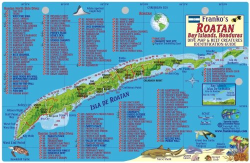
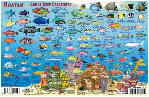
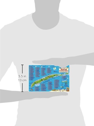
Perfect for divers, snorkelers and nature lovers! Side One is a minimap of Isla de Roatan, Bay Islands, Honduras, with 174 dive sites named and located. Side Two is a reef creatures identification guide with more than 80 species illustrated and named. This convenient, waterproof reference is made of rigid, laminated plastic with hole for lanyard. 5.5' x 8.5'
⚠️ WARNING (California Proposition 65):
This product may contain chemicals known to the State of California to cause cancer, birth defects, or other reproductive harm.
For more information, please visit www.P65Warnings.ca.gov.
- Q: What are the dimensions of the Roatan Honduras Dive Map? A: The Roatan Honduras Dive Map measures five point five inches by eight point five inches. It is designed to be a compact and portable reference for divers and snorkelers.
- Q: Is the map waterproof? A: Yes, the map is waterproof. It is made from rigid, laminated plastic, ensuring it withstands exposure to water while providing durability.
- Q: How many dive sites are featured on the map? A: The map features one hundred seventy-four dive sites. Each site is named and located for easy navigation during diving or snorkeling.
- Q: What type of binding does the map have? A: The map has a map binding. This allows it to open easily and lay flat, making it user-friendly for outdoor activities.
- Q: Who is the author of the dive map? A: The author of the dive map is Franko Maps Ltd. They specialize in creating detailed and accurate maps for various locations.
- Q: Is this guide suitable for beginners? A: Yes, the guide is suitable for beginners. It provides clear illustrations and names for over eighty reef creatures, making identification easy.
- Q: How can I carry the dive map while diving? A: The dive map includes a hole for a lanyard. This allows you to securely attach it for easy access while enjoying your underwater adventures.
- Q: Is this dive map suitable for snorkeling? A: Yes, this dive map is ideal for snorkeling. It provides essential information for both divers and snorkelers about dive sites and marine life.
- Q: How do I clean the laminated map? A: You can clean the laminated map with a damp cloth. This will help maintain its clarity and protect it from wear during use.
- Q: Does the dive map include a guide to reef creatures? A: Yes, the map includes a guide to reef creatures. It features illustrations and names for more than eighty species found in the waters of Roatan.
- Q: Can I use the map in saltwater conditions? A: Yes, the map is suitable for use in saltwater conditions. Its waterproof material ensures it remains intact and functional in marine environments.
- Q: What is the best way to store the dive map when not in use? A: The best way to store the dive map is in a cool, dry place. Keeping it flat will prevent any bending or damage to the laminated surface.
- Q: Is the map designed for repeated outdoor use? A: Yes, the map is designed for repeated outdoor use. Its durable, laminated construction ensures it can withstand various environmental conditions.
- Q: Are there any hazardous materials in the map? A: No, there are no hazardous materials in the map. It is made from safe, non-toxic materials suitable for all users.
- Q: What should I do if the map arrives damaged? A: If the map arrives damaged, you should contact customer support for a replacement. Most sellers have policies in place to address such issues.