
Title
Santa Fe, Truchas Peak Map (National Geographic Trails Illustrated Map, 731)
Sold by Ergodebooks, an authorized reseller.
Returns accepted within 30 days | support@ergodebooks.com
Shipping Information
- Free Standard Shipping — United States only
- Processing Time: 3–5 business days
- Estimated Delivery: 6–10 business days after dispatch
- Double-boxed, fully insured & discreetly packaged
- Tracking number sent via email once dispatched
Returns & Refund
Returns accepted within 30 days of delivery.
Damaged or Defective Item
Free return shipping + replacement or full refund
Wrong Item Received
Free return shipping + replacement or full refund
Change of Mind
Return shipping at customer's expense · 25% restocking fee applies
Payment Option

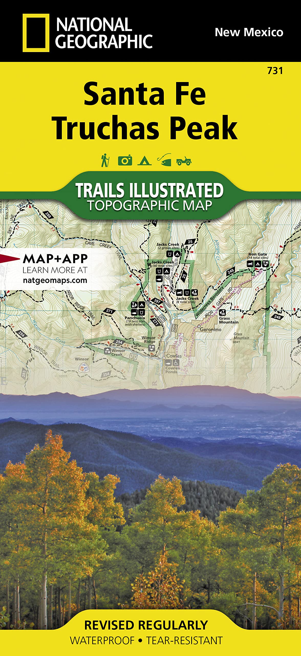
Waterproof Tearresistant Topographic Mapnational Geographic'S Trails Illustrated Map Of The Truchas Peak And Santa Fe Was Designed For All Outdoor Enthusiasts Enjoying The Recreational Opportunities Around Santa Fe. Expertly Researched And Created In Cooperation With The U.S. Forest Service And Others, The Map Covers The Area'S Wide Range Of Public Recreation Lands With Unparalleled Detail. Coverage Includes Santa Fe And Carson National Forests; Pecos Wilderness, River And National Historical Park; Picuris, Nambe, Tesuque Pueblos; Morphy Lake And Hyde Memorial State Parks; Santa Fe Canyon Preserve; And Open Space Parks.Get Off The Beaten Bath And Back On Again By Following The Map Along Clearly Mapped Trails, Shown With Mileage Markers And Colored For Motorized Or Nonmotorized Use, Including The Area'S National Recreation Trails. Your Navigation Will Be Aided By The Map'S Contour Lines, Elevations, Labeled Peaks And Summits, Water Features, Numbered Forest Service Roads And Clear Colorcoded Boundaries For Different Land Designations. Those Preferring To Explore By Road Will Find The El Camino Real, Santa Fe Trail, Historic Route 66 And High Road To Taos Scenic Byways, All Shown With Their Roadside Points Of Interest. Other Recreation Features Include Trailheads, Interpretive Trails, Campgrounds, Rv Campgrounds And Dump Stations, Crosscountry Ski Trails, Alpine Ski Areas, Boat Ramps, Canoe And Fishing Areas, Lookout Towers And Scenic Viewpoints.Every Trails Illustrated Map Is Printed On Backcountry Tough Waterproof, Tearresistant Paper. A Full Utm Grid Is Printed On The Map To Aid With Gps Navigation.Other Features Found On This Map Include: Carson National Forest, Pecos National Historical Park, Pecos Wilderness, Rincon Mountains, Santa Fe, Santa Fe Baldy, Santa Fe National Forest, Truchas Peak. Map Scale = 1:63,360 Sheet Size = 37.75 X 25.5 Folded Size = 4.25 X 9.25
⚠️ WARNING (California Proposition 65):
This product may contain chemicals known to the State of California to cause cancer, birth defects, or other reproductive harm.
For more information, please visit www.P65Warnings.ca.gov.
- Q: What are the dimensions of the Santa Fe, Truchas Peak Map? A: The map measures thirty-seven point seventy-five inches by twenty-five point five inches when unfolded and four point twenty-five inches by nine point twenty-five inches when folded.
- Q: What is the scale of the Santa Fe, Truchas Peak Map? A: The map scale is one to sixty-three thousand three hundred sixty, providing detailed topographic information for outdoor navigation.
- Q: How many pages does the Santa Fe, Truchas Peak Map have? A: The map contains two pages, making it easy to reference while exploring.
- Q: What material is the Santa Fe, Truchas Peak Map made of? A: The map is printed on 'Backcountry Tough' waterproof and tear-resistant paper, ensuring durability in outdoor conditions.
- Q: What type of binding does the Santa Fe, Truchas Peak Map use? A: The map features a foldable binding, allowing for convenient storage and easy unfolding during use.
- Q: Who is the author of the Santa Fe, Truchas Peak Map? A: The map is authored by National Geographic Maps - Trails Illustrated, known for their expertise in outdoor mapping.
- Q: How do I use the Santa Fe, Truchas Peak Map for navigation? A: To use the map for navigation, unfold it and follow the clearly marked trails, paying attention to the mileage markers and contour lines.
- Q: Is the Santa Fe, Truchas Peak Map suitable for both motorized and non-motorized use? A: Yes, the map includes trails that are color-coded for both motorized and non-motorized use, catering to various outdoor activities.
- Q: Can I use the Santa Fe, Truchas Peak Map for GPS navigation? A: Yes, a full UTM grid is printed on the map to assist with GPS navigation, enhancing your outdoor experience.
- Q: What recreational features are highlighted on the Santa Fe, Truchas Peak Map? A: The map highlights features like trailheads, campgrounds, scenic viewpoints, and various recreational trails for outdoor activities.
- Q: How should I store the Santa Fe, Truchas Peak Map? A: Store the map in a cool, dry place, and keep it folded to maintain its condition and prevent damage.
- Q: Is the Santa Fe, Truchas Peak Map waterproof? A: Yes, the map is waterproof, allowing it to withstand rain and moisture during outdoor adventures.
- Q: What should I do if the Santa Fe, Truchas Peak Map arrives damaged? A: If the map arrives damaged, contact the retailer for return instructions or a replacement, ensuring you have a usable product.
- Q: Are there any specific care instructions for the Santa Fe, Truchas Peak Map? A: To care for the map, avoid exposure to extreme heat and direct sunlight, and keep it clean by wiping it with a damp cloth.
- Q: Is the Santa Fe, Truchas Peak Map suitable for beginners? A: Yes, the map is suitable for beginners, as it provides clear trail markings and essential information for easy navigation.
- Q: How does the Santa Fe, Truchas Peak Map compare to other travel maps? A: The Santa Fe, Truchas Peak Map offers unparalleled detail and is specifically designed for outdoor enthusiasts, setting it apart from standard travel maps.