
Title
Sawtooth National Recreation Area Map (National Geographic Trails Illustrated Map, 870)
Sold by Ergodebooks, an authorized reseller.
Returns accepted within 30 days | support@ergodebooks.com
Shipping Information
- Free Standard Shipping — United States only
- Processing Time: 3–5 business days
- Estimated Delivery: 6–10 business days after dispatch
- Double-boxed, fully insured & discreetly packaged
- Tracking number sent via email once dispatched
Returns & Refund
Returns accepted within 30 days of delivery.
Damaged or Defective Item
Free return shipping + replacement or full refund
Wrong Item Received
Free return shipping + replacement or full refund
Change of Mind
Return shipping at customer's expense · 25% restocking fee applies
Payment Option

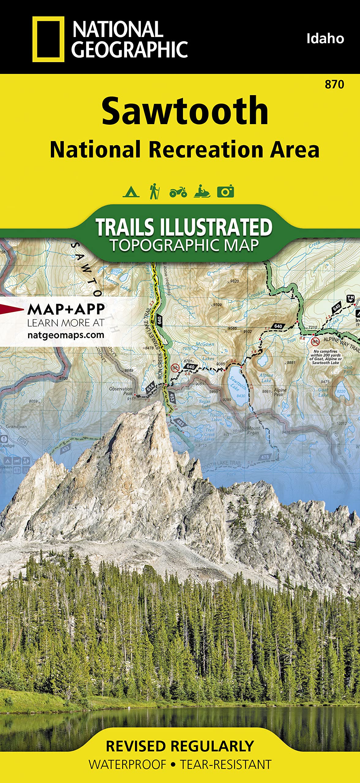
Waterproof Tearresistant Topographic Mapthe Sawtooth National Recreation Area, Located In The Heart Of Central Idaho, Boasts Three Wilderness Areas: The Sawtooth Wilderness, Cecil D. Andruswhite Clouds Wilderness, And Hemingwayboulders Wilderness, Three Mountain Ranges: Sawtooth Range, Boulder Mountains And White Cloud Peaks And Portions Of The Smoky And Pioneer Mountains. The Headwaters Of Four Major River Systems Originate In The Nra, Including The Salmon River, Which Starts Its Four Hundredmile Journey West From The Sawtooth Valley.Over 300 Highalpine Lakes, Forty Peaks Rising Over 10,000 Feet, And Hundreds Of Miles Of Trails In The Sawtooth Nra Create Countless Opportunities For Recreation Including: Cross Country Skiing And Mountain Biking Near Galena Summit, Boating On Redfish Lake, And Floating The Salmon River.With Hundreds Of Miles Of Mapped Trails This Map Can Guide You Off The Beaten Path And Back Again In Some Of The Most Breathtaking Scenery In The Region. Trail Mileages, Trail Use And Seasonal Closures Will Assist In Choosing The Path That Is Right For You. Recreation Features Are Clearly Marked, Including Campgrounds, Trailheads, Whitewater Access Points, Interpretive Trails, Boat Launches, Nordic Ski Areas, And Other Points Of Interest. The Map Base Includes Contour Lines, Shaded Relief, And Elevations For Summits, Passes And Many Lakes.Every Trails Illustrated Map Is Printed On Backcountry Tough Waterproof, Tearresistant Paper. A Full Utm Grid Is Printed On The Map To Aid With Gps Navigation. Map Scale = 1:75,000 Sheet Size = 25.5 X 37.75 Folded Size = 4.25 X 9.25
⚠️ WARNING (California Proposition 65):
This product may contain chemicals known to the State of California to cause cancer, birth defects, or other reproductive harm.
For more information, please visit www.P65Warnings.ca.gov.
- Q: What are the dimensions of the Sawtooth National Recreation Area Map? A: The map measures twenty-five point five inches by thirty-seven point seven five inches when unfolded and four point twenty-five inches by nine point twenty-five inches when folded.
- Q: What material is the Sawtooth National Recreation Area Map made of? A: The map is printed on waterproof and tear-resistant 'Backcountry Tough' paper, ensuring durability in outdoor conditions.
- Q: How many pages does the Sawtooth National Recreation Area Map have? A: The map does not have pages; it is a single foldable map designed for easy handling and navigation.
- Q: How do I use the Sawtooth National Recreation Area Map? A: Open the map to view topographic details and trails for navigation. Use the UTM grid for GPS compatibility while exploring.
- Q: Is this map suitable for beginners? A: Yes, the Sawtooth National Recreation Area Map is suitable for users of all skill levels, providing detailed trail information for everyone.
- Q: Can I use this map for boating and mountain biking? A: Yes, the map includes recreation features for boating on Redfish Lake and mountain biking trails near Galena Summit.
- Q: How do I keep the Sawtooth National Recreation Area Map in good condition? A: Store the map flat or folded in a dry place to prevent water damage. Clean with a damp cloth if needed.
- Q: Is the map safe to use in wet conditions? A: Yes, the map is waterproof, making it safe to use in wet conditions without worrying about damage.
- Q: What should I do if my map arrives damaged? A: Contact customer service for a replacement or refund if your map arrives damaged or defective.
- Q: Does this map include seasonal trail closures? A: Yes, the map features seasonal closures and trail use information, helping you choose the best paths for your adventure.
- Q: What recreational activities can I do with this map? A: You can use the map for various activities, including hiking, cross-country skiing, and floating on the Salmon River.
- Q: Are campgrounds marked on the map? A: Yes, the map clearly marks campgrounds, trailheads, and other points of interest for your convenience.
- Q: Does the map provide elevation details? A: Yes, it includes contour lines and elevations for summits, passes, and many lakes within the Sawtooth National Recreation Area.
- Q: Is the Sawtooth National Recreation Area Map eco-friendly? A: The map is printed on durable materials, but specific eco-friendly certifications are not mentioned.
- Q: Can I use this map for GPS navigation? A: Yes, a full UTM grid is printed on the map to assist with GPS navigation while you explore the area.