
Title
Taos, Wheeler Peak Map (National Geographic Trails Illustrated Map, 730)
Sold by Ergodebooks, an authorized reseller.
Returns accepted within 30 days | support@ergodebooks.com
Shipping Information
- Free Standard Shipping — United States only
- Processing Time: 3–5 business days
- Estimated Delivery: 6–10 business days after dispatch
- Double-boxed, fully insured & discreetly packaged
- Tracking number sent via email once dispatched
Returns & Refund
Returns accepted within 30 days of delivery.
Damaged or Defective Item
Free return shipping + replacement or full refund
Wrong Item Received
Free return shipping + replacement or full refund
Change of Mind
Return shipping at customer's expense · 25% restocking fee applies
Payment Option

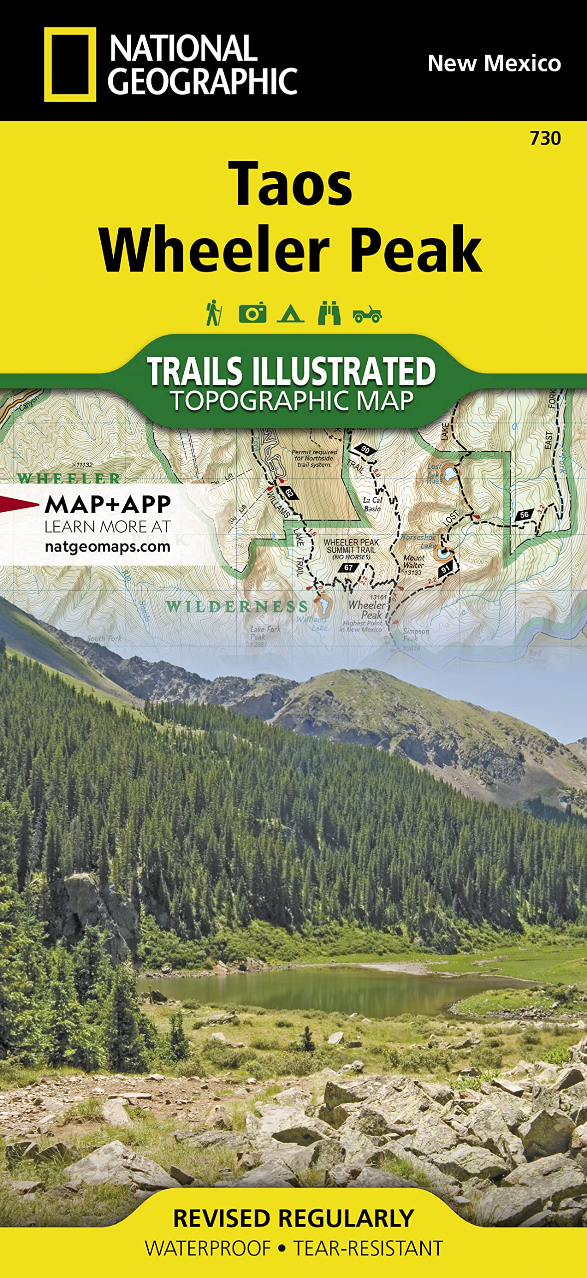
Waterproof Tearresistant Topographic Mapthe Northern New Mexico Town Of Taos Lies In The High Desert Bounded By The Sangre De Cristo Mountains. In Those Mountains Northeast Of The Town, Wheeler Peak Rises, The Highest Natural Point In New Mexico. Expertly Researched And Created In Partnership With Local Land Management Agencies, National Geographic'S Trails Illustrated Map Of Taos, Wheeler Peak Provides An Unparalleled Tool For Exploring This Unique Region Of Historic Pueblos, Scenic Rivers, Enchanting Desert, And Picturesque Mountains. Some Of The Many Key Areas Of Interest Included Are Carson National Forest; Rio Grande Del Norte National Monument; Portions Of Rio Honda And Red River; Coyote Creek State Park; Wheeler Peak And Latir Peak Wilderness Areas; Eagle Nest Lake State Park; Colin Neblett State Wildlife Area; And Taos Pueblo, A Unesco World Heritage Site.With Miles Of Mapped Trails Including Columbine Twining National Recreation Trail And Select Mountain Bike Routes, This Map Will Prove Handy In Guiding You Off The Beaten Path And Back Again. Trail Mileage Between Intersections Will Help You Choose The Path That'S Right For You. The Wild Rivers And Enchanted Circle Scenic Byways Are Noted For Those Wishing To Take In The Scenery By Car. Recreation Features Are Clearly Marked, Including Campgrounds, Trailheads, Interpretive Trails, Fishing Areas, Boat Ramps, Whitewater Access, Horse Camps, And Ski Areas. The Map Base Includes Contour Lines And Elevations For Summits, Passes And Lakes.Every Trails Illustrated Map Is Printed On Backcountry Tough Waterproof, Tearresistant Paper. A Full Utm Grid Is Printed On The Map To Aid With Gps Navigation.Other Features Found On This Map Include: Agua Fria Peak, Baldy Mountain, Carson National Forest, Cerro Vista, Eagle Nest Lake, Latir Peak Wilderness, Palo Flechado Pass, Wheeler Peak, Wheeler Peak Wilderness. Map Scale = 1:63,360 Sheet Size = 37.5 X 25.25 Folded Size = 4.25 X 9.25
⚠️ WARNING (California Proposition 65):
This product may contain chemicals known to the State of California to cause cancer, birth defects, or other reproductive harm.
For more information, please visit www.P65Warnings.ca.gov.
- Q: What are the dimensions of the Taos, Wheeler Peak Map? A: The map measures thirty-seven point five inches by twenty-five point twenty-five inches when unfolded and four point twenty-five inches by nine point twenty-five inches when folded.
- Q: What type of paper is the map printed on? A: The map is printed on waterproof, tear-resistant paper designed for durability in outdoor conditions.
- Q: How many pages does the map have? A: The map contains two pages, providing detailed information and visuals for outdoor exploration.
- Q: How do I use the Taos, Wheeler Peak Map for navigation? A: You can use the map by following the marked trails and utilizing the full UTM grid for GPS navigation.
- Q: Is the map suitable for both hiking and driving? A: Yes, the map includes mileage for hiking trails and notes scenic byways for those who prefer to drive.
- Q: Can I use this map for mountain biking? A: Yes, the map indicates select mountain bike routes, making it suitable for biking enthusiasts.
- Q: How should I store the map to maintain its condition? A: To keep the map in good condition, store it flat in a cool, dry place, away from direct sunlight.
- Q: Is the map safe to use in wet conditions? A: Yes, the map's waterproof material makes it safe and functional for use in wet conditions.
- Q: How do I clean the map if it gets dirty? A: You can clean the map by gently wiping it with a damp cloth; avoid using harsh chemicals.
- Q: Is this map suitable for beginners? A: Yes, the map is suitable for beginners as it clearly marks trails and includes helpful navigation features.
- Q: How does this map compare to other hiking maps? A: This map offers detailed topographic information and is specifically designed for the Taos area, unlike many general hiking maps.
- Q: What if the map arrives damaged? A: If the map arrives damaged, you can return it for a replacement or refund within the specified return policy period.
- Q: Does the map include campgrounds and fishing areas? A: Yes, the map clearly marks campgrounds, fishing areas, and other recreation features for outdoor activities.
- Q: Are there any age restrictions for using this map? A: There are no age restrictions for using the map; it is designed for anyone interested in exploring the Taos area.
- Q: What are the key areas of interest included on the map? A: Key areas include Carson National Forest, Rio Grande Del Norte National Monument, and Taos Pueblo, a UNESCO World Heritage Site.
- Q: Can I use this map for winter sports? A: Yes, the map includes ski areas and features useful for winter sports enthusiasts.