
Title


Toronto Map (National Geographic Destination City Map),Used
Sold by Ergodebooks, an authorized reseller.
Returns accepted within 30 days | support@ergodebooks.com
Shipping Information
- Free Standard Shipping — United States only
- Processing Time: 3–5 business days
- Estimated Delivery: 6–10 business days after dispatch
- Double-boxed, fully insured & discreetly packaged
- Tracking number sent via email once dispatched
Returns & Refund
Returns accepted within 30 days of delivery.
Damaged or Defective Item
Free return shipping + replacement or full refund
Wrong Item Received
Free return shipping + replacement or full refund
Change of Mind
Return shipping at customer's expense · 25% restocking fee applies
Payment Option

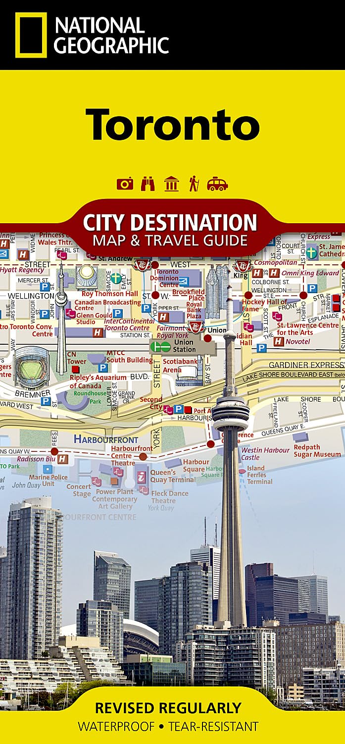
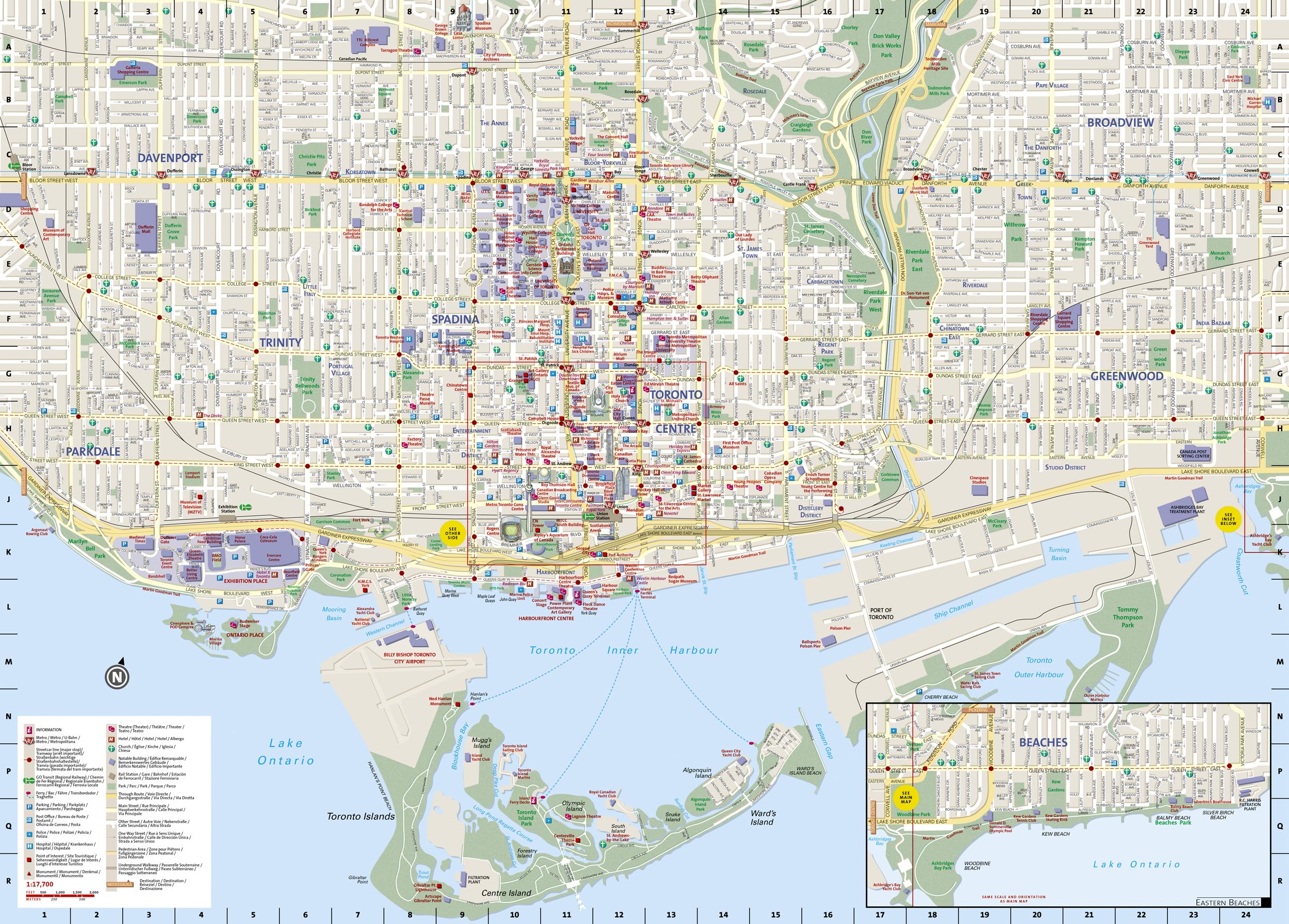
Waterproof TearResistant Travel MapNational Geographic's City Destination map of Toronto was designed for business and leisure travelers alike. Canada's capital city is covered with unparalleled detail in a unique package that combines a easy to read street map and travel guide. A regional map and an inset map of the city center, along with information about the city and its points of interest are featured on the front side of the map. A user friendly index of streets, hotels, public buildings, points of interest, metro stations, parks and beaches will help you find your destination quickly. While an overview of the transit system, a comprehensive metro map and map of Toronto Pearson International Airport will aid in your navigation around the city.A detailed street map of the city is shown on the reverse side, including the Toronto Islands. as well as an inset map of the Eastern Beaches. Points of interest, theaters, monuments, hotels, churches, parks, visitor information centers, notable buildings, underground walkways and pedestrian areas are clearly marked and easy to find with the multilanguage legend. Many popular attractions are depicted in 3D, including the CN Tower, Ontario Parliament Buildings and Eaton Center. The location of train and metro stations, ferry routes and parking areas will further assist your exploration of the city.Every Destination Map is printed on durable synthetic paper, making them waterproof, tearresistant and tough capable of withstanding the rigors of any kind of travel. Map Scale = 1:17,700 Sheet Size = 24.75" x 17.75" Folded Size = 4" x 8.75"
⚠️ WARNING (California Proposition 65):
This product may contain chemicals known to the State of California to cause cancer, birth defects, or other reproductive harm.
For more information, please visit www.P65Warnings.ca.gov.
- Q: What are the dimensions of the Toronto map? A: The Toronto map measures twenty-four point seventy-five inches by seventeen point seventy-five inches when unfolded and four inches by eight point seventy-five inches when folded.
- Q: What material is the Toronto map made of? A: The Toronto map is printed on durable synthetic paper, making it waterproof and tear-resistant, ideal for travel.
- Q: How detailed is the map of Toronto? A: The map features unparalleled detail, including a comprehensive street map and an inset map of the city center.
- Q: How do I use the Toronto map for navigation? A: You can use the map for navigation by following the user-friendly index of streets and points of interest listed on the front.
- Q: Is this map suitable for tourists visiting Toronto? A: Yes, the map is designed for both business and leisure travelers, making it ideal for tourists exploring the city.
- Q: Can I find public transport information on the map? A: Yes, the map includes an overview of the transit system and a comprehensive metro map for easy navigation.
- Q: How can I keep the Toronto map in good condition? A: To maintain the map’s condition, store it flat or folded as needed and avoid exposure to extreme moisture beyond its waterproof capabilities.
- Q: Is the Toronto map safe to use outdoors? A: Yes, the map is waterproof and tear-resistant, making it safe and durable for outdoor use.
- Q: What should I do if my map arrives damaged? A: If your map arrives damaged, contact customer support for assistance with returns or exchanges.
- Q: Does the map mark popular attractions? A: Yes, many popular attractions in Toronto, such as the CN Tower and Eaton Center, are clearly marked on the map.
- Q: Are there any user-friendly features on the map? A: Yes, the map includes a multi-language legend and a friendly index for easily finding locations.
- Q: Is this map appropriate for children to use? A: Yes, the map is designed to be user-friendly, making it suitable for all ages, including children.
- Q: What type of binding does the Toronto map have? A: The Toronto map is bound as a map, allowing for easy folding and unfolding during use.
- Q: Can I use the map for cycling around Toronto? A: Yes, the detailed street maps and points of interest make it suitable for cycling as well as walking.
- Q: What are the key features of the Toronto map? A: Key features include waterproof material, tear-resistant design, detailed street maps, and marked points of interest.
- Q: How does this map compare to others for Toronto? A: This map offers unparalleled detail and user-friendly features, making it superior for both tourists and locals compared to others.