
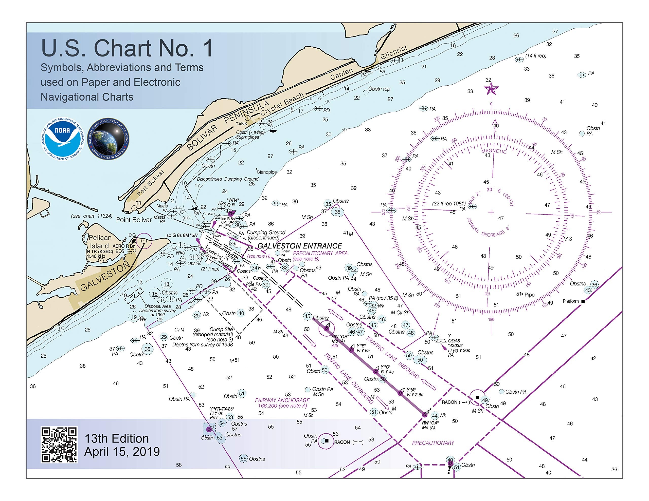
Title
U.S. Chart No. 1 13Th Edition: Symbols, Abbreviations And Terms Used On Paper And Electronic Navigational Charts
Sold by Ergodebooks, an authorized reseller.
Returns accepted within 30 days | support@ergodebooks.com
Shipping Information
- Free Standard Shipping — United States only
- Processing Time: 3–5 business days
- Estimated Delivery: 6–10 business days after dispatch
- Double-boxed, fully insured & discreetly packaged
- Tracking number sent via email once dispatched
Returns & Refund
Returns accepted within 30 days of delivery.
Damaged or Defective Item
Free return shipping + replacement or full refund
Wrong Item Received
Free return shipping + replacement or full refund
Change of Mind
Return shipping at customer's expense · 25% restocking fee applies
Payment Option

This 130 Page Book Describes The Symbols, Abbreviations, And Terms Used On Paper Noaa Nautical Charts And For Displaying Noaa Electronic Navigational Chart (Noaa Enc?) Data On Electronic Chart Display And Information Systems (Ecdis). The Document Also Shows Paper Chart Symbols Used By The National Geospatialintelligence Agency And Symbols Specified By The International Hydrographic Organization. In The Back Of U.S. Chart 1, There Is Additional Information About The Characteristics And Appearance Of Buoys Conforming To The Iala Maritime Buoyage System That Is Used By The United States And Most Other Seafaring Nations. Some Of The Changes Implemented In This New Addition Are Listed In The Table Below. Chart No. 1 Symbol Change Description C 21 Extended Use Of The Dashed Intermediate River Line Symbol To Also Represent Intermediate Lakes. D 11 Added New Noaa Light Gray Line Symbol For Hard Surface Road. F 29.2 Added Symbol For Bubble Curtain. Also Called A Pneumatic Barrier, These Consist Of Perforated Pipe Affixed Near Shore To The Bottom Of A Body Of Water. As Air Is Forced Through The Pipe, Rising Bubbles Cause A Wall Of Water To Flow Upward. The Effect Can Stop Or Slow The Passage Of Spilled Oil Or Fish From Passing Through The Barrier. H R H S Deleted Entries For Obsolete New Moon And Full Moon Symbols, Which At One Time Accompanied Chart Tide Tables. H T Deleted Entry For Current Diagram Symbol, Also Called A Current Rose. These Symbols Are Being Removed On The Next Editions Of The Few Charts In New England In Which They Currently Appear. K 47 Deleted The Text Based Oyster Bed Symbol. Noaa Now Uses The International Symbol For Shellfish Bed. K A Changed Description Of This Symbol From Rock Awash To Rock Which Covers And Uncovers, (Height Unknown) To Align With K 11, Which Shows The Same Feature, But For Which A Height Is Known. N 12.2 N 12.3 Added Typical Noaa Representations For Anchorages That Reference The Us Code Of Federal Regulations (Cfr). Text Of Relevant Sections Of The Cfr Are Reprinted In Chapter 2 Of Each Volume Of The Us Coast Pilot?. N 13 Deleted Text Based Symbol For Seaplane Operating Area. P 30.1 P 40.1 Deleted The Symbols Shown For Noaa And Nga, Which Were Incorrect. Both Agencies Portray Directional And Sector Lights In A Manner Similar To That Shown By The International Symbols. Q 5153 Q 5557 Q 5963 Deleted Entries For Many Specific Types Of Special Purpose Buoys And Added The Note, Purpose Of Buoy May Be Shown By Label. Q 130.1 Added The Island Of Taiwan To The List Of Western Pacific Areas, Which Use The Iala B Buoyage System. Q 130.7 Deleted The Q 63 Entry For Emergency Wreck Marking Buoy And Moved The Renamed Aid, New Danger Mark To Q 130.7. Paper Chart And Ecdis Symbols Are Now Shown, As Well As A Depiction Of The Buoy In Appendix 1. S 4 S 5 Deleted Noaa Symbols For Radar Reflectors, Which Are Not Shown On Noaa Charts. S 18.17 Added Paper Chart And Ecdis Examples For Each Type Of Virtual Automatic Identification System (Vais) Aid To Navigation Symbol. T 26 T27 Deleted Entries For Distress Signal Station And Telegraph Station. Other Types Of Signal Stations Remain. Appendix 1 Added Depiction Of A New Danger Mark In The Appendix That Shows Examples Of The Aids To Navigation In The Iala Maritime Buoyage System. A New Danger Mark Entry Was Also Added At Q 130.7.
⚠️ WARNING (California Proposition 65):
This product may contain chemicals known to the State of California to cause cancer, birth defects, or other reproductive harm.
For more information, please visit www.P65Warnings.ca.gov.
- Q: What are the dimensions of this book? A: The dimensions of this book are eleven inches in length, eight and a half inches in height, and zero point five one inches in width.
- Q: How many pages does the book contain? A: This book contains one hundred thirty-six pages detailing navigational symbols and terms.
- Q: What type of binding does this book have? A: The book features spiral binding, allowing for easy use while navigating.
- Q: How do I use this book for navigation? A: To use this book, refer to the symbols and terms provided for understanding paper and electronic navigational charts.
- Q: Is this book suitable for beginners? A: Yes, this book is suitable for both beginners and experienced navigators as it clearly explains essential symbols.
- Q: What age group is this book appropriate for? A: This book is appropriate for individuals interested in navigation, but there are no specific age restrictions.
- Q: How should I store this book to keep it in good condition? A: Store the book in a cool, dry place and avoid exposure to direct sunlight to preserve its quality.
- Q: Can I clean the book if it gets dirty? A: Yes, you can gently wipe the cover with a damp cloth to remove any dirt or smudges.
- Q: Is this book safe for marine environments? A: Yes, the book is designed to withstand marine conditions, but protect it from excessive moisture.
- Q: How does this book compare to other nautical guides? A: This book is focused specifically on symbols and terms, making it a specialized resource compared to broader nautical guides.
- Q: Should I choose this book over other editions? A: Yes, this thirteenth edition includes the latest updates and symbol changes, making it a relevant choice.
- Q: What if the book arrives damaged? A: If the book arrives damaged, you can return it within the specified return period for a replacement.
- Q: Is there a warranty for this book? A: Books typically do not come with a warranty, but check with the seller for their specific policies.
- Q: What if I have trouble understanding the symbols? A: You can refer to additional online resources or consult with experienced navigators for further clarification.
- Q: Are there any symbols that have been removed in this edition? A: Yes, several obsolete symbols have been removed in this new edition to streamline navigation.
- Q: Does this book include electronic chart symbols? A: Yes, it covers both paper chart symbols and symbols used for electronic navigational charts.