If you have any questions, you are always welcome to contact us. We'll get back to you as soon as possible, withing 24 hours on weekdays.
Customer service
All questions about your order, return and delivery must be sent to our customer service team by e-mail at yourstore@yourdomain.com
Sale & Press
If you are interested in selling our products, need more information about our brand or wish to make a collaboration, please contact us at press@yourdomain.com
Help
If you have any questions, you are always welcome to contact us. We'll get back to you as soon as possible, withing 24 hours on weekdays.
Customer service
All questions about your order, return and delivery must be sent to our customer service team by e-mail at yourstore@yourdomain.com
Sale & Press
If you are interested in selling our products, need more information about our brand or wish to make a collaboration, please contact us at press@yourdomain.com
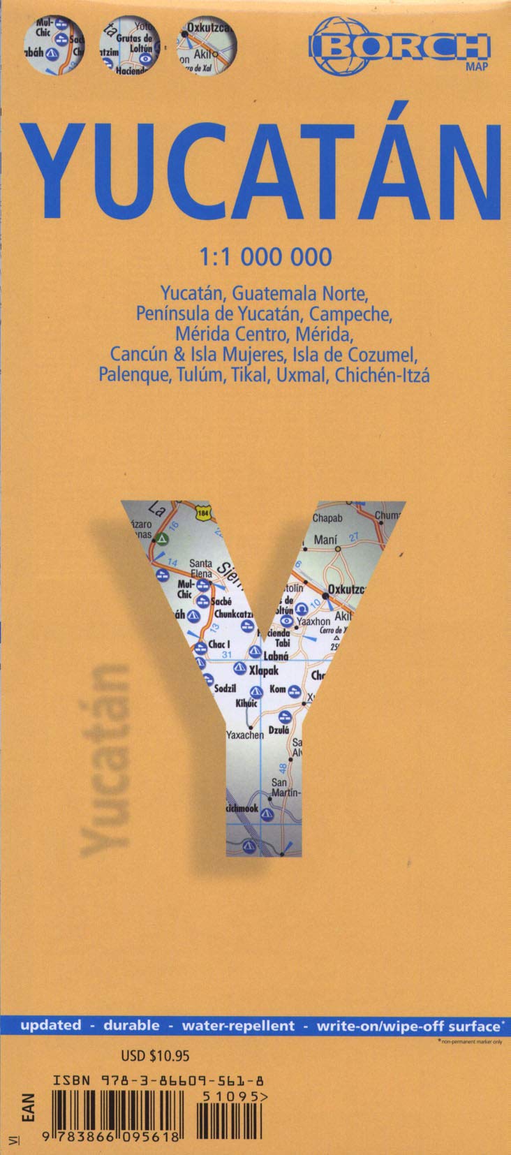
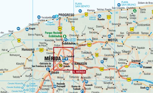
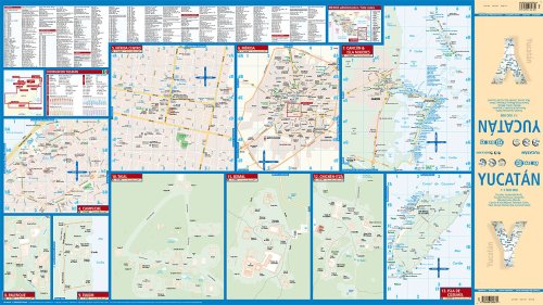
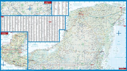
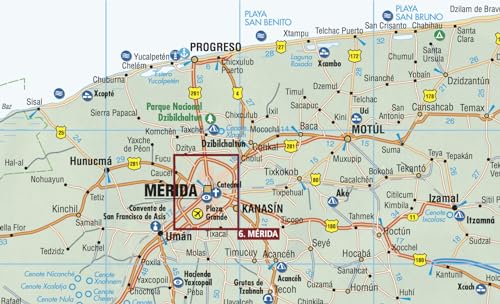
DRYERASE MARKINGS WIPE CLEAN /// BIODEGRADABLE LAMINATION /// PATENTED FOLD IS EASY TO USE /// Laminated road and travel map in vibrant color. Forget scrolling on a tiny screen, this map shows you the best things to do and places to see in the Yucatan. If you'll be driving, this map helps you choose the best destinations, the best routes to get there, and where to park when you arrive. Shows you which routes are best by distinguishing road sizes ranging from expressways (free and toll) to country lanes. Legend includes railways, Maya temples, archaeological sites, sights to see, museums, monuments, castles, churches, monasteries, caves, beaches, yachting, shipwrecks, hospitals, golf courses, bus stations, parking, car ferries, waterfalls, camping sites, international airports, airfields, hotels, shopping centers, national parks, nature reserves, mangrove wetlands. Includes inset map of Guatemala North (1:1,000,000), Yucatan Peninsula (1:2,500,000), Campeche (1:10,000), Merida Downtown (1:10,000), Merida (1:100,000), Cancun & Isla Mujeres (1:100,000), Palenque, Tulum, Tikal, Uxmal, ChichenItza, Cozumel Island (1:250,000). Climate charts show the average daily temperatures, humidity, hours of sunshine and precipitation for each month. Extensive index. Main map scale 1:1,000,000.
⚠️ WARNING (California Proposition 65):
This product may contain chemicals known to the State of California to cause cancer,
birth defects, or other reproductive harm.
<div class="dynamic-checkout__content" id="dynamic-checkout-cart" data-shopify="dynamic-checkout-cart"> <shopify-accelerated-checkout-cart wallet-configs="[{"supports_subs":true,"supports_def_opts":false,"name":"shop_pay","wallet_params":{"shopId":73758048501,"merchantName":"Ergodebooks","personalized":true}},{"supports_subs":false,"supports_def_opts":false,"name":"amazon_pay","wallet_params":{"checkoutLanguage":"en_US","ledgerCurrency":"USD","placement":"Cart","sandbox":false,"merchantId":"A1G1ZY975O1T6J","productType":"PayAndShip","design":"C0002"}},{"supports_subs":true,"supports_def_opts":false,"name":"paypal","wallet_params":{"shopId":73758048501,"countryCode":"US","merchantName":"Ergodebooks","phoneRequired":true,"companyRequired":false,"shippingType":"shipping","shopifyPaymentsEnabled":true,"hasManagedSellingPlanState":false,"requiresBillingAgreement":false,"merchantId":"L873BZSC9NMQS","sdkUrl":"https://www.paypal.com/sdk/js?components=buttons\u0026commit=false\u0026currency=USD\u0026locale=en_US\u0026client-id=AbasDhzlU0HbpiStJiN1KRJ_cNJJ7xYBip7JJoMO0GQpLi8ePNgdbLXkC7_KMeyTg8tnAKW4WKrh9qmf\u0026merchant-id=L873BZSC9NMQS\u0026intent=authorize"}}]" access-token="c0f52a66b386e9fa5c0ab4c2febc737c" buyer-country="US" buyer-locale="en" buyer-currency="USD" shop-id="73758048501" cart-id="fc68eaa252348144ebabe355ff8f3883" enabled-flags="["d6d12da0","32a68cd0","a1c7ccbe","ce346acf","c0874428"]" > <div class="wallet-button-wrapper"> <ul class='wallet-cart-grid wallet-cart-grid--skeleton' role="list" data-shopify-buttoncontainer="true"> <li data-testid='grid-cell' class='wallet-cart-button-container'><div class='wallet-cart-button wallet-cart-button__skeleton' role='button' disabled aria-hidden='true'> </div></li><li data-testid='grid-cell' class='wallet-cart-button-container'><div class='wallet-cart-button wallet-cart-button__skeleton' role='button' disabled aria-hidden='true'> </div></li><li data-testid='grid-cell' class='wallet-cart-button-container'><div class='wallet-cart-button wallet-cart-button__skeleton' role='button' disabled aria-hidden='true'> </div></li> </ul> </div> </shopify-accelerated-checkout-cart> <small id="shopify-buyer-consent" class="hidden" aria-hidden="true" data-consent-type="subscription"> One or more of the items in your cart is a recurring or deferred purchase. By continuing, I agree to the <span id="shopify-subscription-policy-button">cancellation policy</span> and authorize you to charge my payment method at the prices, frequency and dates listed on this page until my order is fulfilled or I cancel, if permitted. </small> </div>
Stay in the know
Subscribe to our newsletter and stay updated on latest offers, discounts and events near you.
For MAP (Minimum Advertised Price) violations and Intellectual Property (IP) or Trademark concerns, please contact:
support@ergodebooks.com
⚠️ California Proposition 65 Warning: Some products sold on this website may expose you to chemicals known to the State of California to cause cancer, birth defects, or other reproductive harm. For more information, visit www.P65Warnings.ca.gov.